




Executive Overview
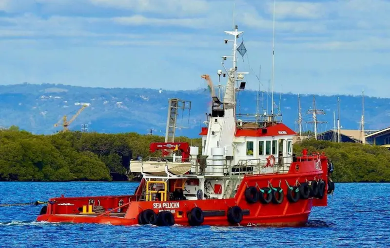
On June 10, 2025, a serious maritime accident occurred in the North Arm waterway of Port Adelaide, South Australia, when the tug Sea Pelican, operating in combination with the barge Rocksea, ran aground on an encroaching sandbank. The impact breached the tug’s hull, causing immediate water ingress into the engine room and forcing the crew to initiate emergency bilge pumping operations. While the vessel was successfully stabilized and slipped for dry-dock repairs the following day without injury or environmental pollution, the incident triggered a comprehensive investigation by the Australian Transport Safety Bureau (ATSB).
The ATSB’s final investigation report exposes a chain of systemic failures, highlighting critical deficiencies in voyage planning, inadequate localized risk assessments, and structural flaws within the vessel operator’s Safety Management System (SMS). Most notably, the investigation revealed a profound regulatory and operational ambiguity regarding the roles and responsibilities of Pilotage Exemption Certificate (PEC) holders when operating alongside a vessel’s primary master.
Owned and operated by Maritime Constructions, a prominent Australian marine infrastructure contractor, the Sea Pelican incident serves as a stark warning to the domestic commercial vessel sector. It underscores the high stakes of navigating restricted waterways without precise bathymetric data and demonstrates how organizational "grey areas" can compromise safety margins in complex port operations.

Detailed Chronology of the Incident
[June 10, 2025: Pre-Departure]
       │
       ▼
[Inadequate Passage Planning & Lack of Sandbank Awareness]
       │
       ▼
[Transit of Tug Sea Pelican & Barge Rocksea through North Arm]
       │
       ▼
[Maneuver Executed Wide at the Junction to Port Adelaide River]
       │
       ▼
[Grounding on Sandbar (Hull Breached / Engine Room Flooding)]
       │
       ▼
[Emergency Bilge Pumping & Vessel Stabilization]
       │
       ▼
[June 11, 2025: Tug Slipped for Dry-Dock Repairs]
Pre-Departure and Environmental Conditions
On the morning of June 10, 2025, the crew of the Sea Pelican prepared to tow the barge Rocksea from its mooring in the North Arm waterway—a narrow branch of the Port Adelaide River characterized by tight bends, industrial docks, and significant sediment movement.
The physical configuration of a tug-and-barge combination inherently reduces maneuverability, increases draft requirements, and alters the hydrodynamic interaction of the vessels with the channel boundaries. Despite these heightened risks, the pre-departure phase was marked by a lack of rigorous, localized risk assessment. The passage plan utilized by the bridge team did not account for recent bathymetric changes in the waterway, nor did it incorporate up-to-date data on siltation patterns.
The Transit and Grounding
With the Sea Pelican securely coupled to the Rocksea, the vessel combination commenced its transit, navigating westward through the North Arm toward the main channel of the Port Adelaide River.
As the combined vessels approached the junction where the North Arm meets the primary river channel, they encountered a critical navigational hazard: an encroaching sandbank that had progressively narrowed the navigable width of the channel. Unaware of the exact boundaries of this shoal, the bridge team initiated a wide turn to ensure the barge cleared the inner radius of the bend.
By swinging wide to accommodate the barge’s turning circle, the tug was steered directly into the shallow margins of the channel. At approximately the peak of the turn, the Sea Pelican made heavy contact with the submerged sandbar.
Emergency Response and Recovery
The impact was immediately felt on board. The physical force of the grounding breached the tug’s steel shell plating, compromising the integrity of the hull adjacent to the engine room.
+-------------------------------------------------------------+
|               EMERGENCY RESPONSE TIMELINE                   |
+-------------------------------------------------------------+
| 1. IMPACT: Tug contacts sandbar; hull plating is holed.     |
| 2. DETECTION: Bilge alarms sound; water in engine room.     |
| 3. MITIGATION: Crew activates high-capacity bilge pumps.    |
| 4. STABILIZATION: Ingress controlled; vessel secured.       |
| 5. RECOVERY (Next Day): Tug is towed and slipped for repair.|
+-------------------------------------------------------------+
As water began rapidly filling the compartment, the crew executed emergency bilge-pumping procedures. The high-capacity pumps successfully managed the rate of water ingress, preventing a catastrophic loss of buoyancy or electrical power.
The vessel was stabilized and held in position before being carefully moved to a local slipway the following day, June 11, 2025, for emergency dry-docking and structural repairs. Due to the rapid response of the crew, no injuries were sustained, and no hazardous fluids were discharged into the Port Adelaide marine environment.
Supporting Context and Maritime Metrics
The Geography of Port Adelaide’s Waterways
Port Adelaide is South Australia’s main maritime gateway, handling millions of tonnes of cargo annually. While the main shipping channels are regularly dredged to accommodate deep-draft commercial ships, auxiliary waterways like the North Arm are subject to different maintenance schedules and rapid siltation.
Sandbanks in tidal estuaries are dynamic structures, shifting in response to tidal currents, heavy weather, and run-off. This makes regular hydrographic surveys and active information sharing between port authorities and vessel operators essential.
+-----------------------------------------------------------------+
|              PORT ADELAIDE NORTH ARM CHANNEL PROFILE            |
+-----------------------------------------------------------------+
|                                                                 |
|   [Northern Bank]                                               |
|   ~~~~~~~~~~~~~~~~~~~~~~~~~~~~~~~~~~~~~~~~~~~~~~~~~~~~~~~~~~~~  |
|         |                                                       |
|         | <--- Safe Navigable Water --->                        |
|         |                                                       |
|   ======x==============================                         |
|            Encroaching Sandbank        [Uncharted Hazard]     |
|           _____________________________                       |
|   ~~~~~~~~~~~~~~~~~~~~~~~~~~~~~~~~~~~~~~~~~~~~~~~~~~~~~~~~~~~~  |
|   [Southern Bank]                                               |
|                                                                 |
+-----------------------------------------------------------------+
The ATSB investigation revealed that while the sandbank’s encroachment was a known physical reality in the area, it had not been integrated into the active navigational materials used by local operators. This created a dangerous discrepancy between the official charts and the actual physical depth of the channel.
Hydrodynamics of Tug-and-Barge Combinations
Operating a tug in combination with a barge significantly alters the handling characteristics of both vessels. Key hydrodynamic factors include:
- Directional Instability: A barge being pushed or towed alongside can act as a massive sail or rudder, resisting the turning forces of the tug.
- Increased Swept Path: During a turn, the combined footprint (the "swept path") of the tug and barge is much wider than that of a single vessel, requiring a wider berth.
- Squat and Shallow Water Effects: As vessels enter shallow waters, pressure drops beneath the hull, causing the vessel to "squat" lower in the water, reducing under-keel clearance (UKC) and making grounding more likely.
On June 10, the bridge team had to balance the risk of grounding the barge on the inside of the turn against the risk of steering the tug too close to the outside of the channel. Lacking precise data on the channel’s actual width, they miscalculated this balance.
Official Statements and Safety Findings
ATSB Findings on Voyage Planning
The Australian Transport Safety Bureau’s investigation focused heavily on passage planning and risk management. ATSB Chief Commissioner Angus Mitchell emphasized that the grounding was a direct consequence of inadequate preparation.
"The masters on board did not have accurate knowledge of the boundaries of the encroaching sandbank, and were unaware of the extent of the resulting narrowing of the navigable channel," Chief Commissioner Mitchell stated. "Pre-departure planning did not sufficiently evaluate the channel width available, or address the sandbank as a navigational hazard."
The ATSB noted that under standard maritime safety codes, a passage plan must be "berth-to-berth." It should identify all known hazards, establish safe speed limits, and define clear go/no-go areas based on the vessel’s draft and tidal heights. The planning for this transit fell short of these standards, relying instead on informal local knowledge that failed to account for recent siltation.
The Pilotage Exemption Certificate (PEC) Dilemma
A key focus of the ATSB’s report was the command structure on the bridge of the Sea Pelican. Under Port Adelaide regulations, a vessel combination of this size is required to carry a licensed harbor pilot or be commanded by a master holding a Pilotage Exemption Certificate (PEC).
Because the designated master of the Sea Pelican did not hold a PEC for Port Adelaide, the operator placed a pilotage-exempt master on board to satisfy regulatory requirements. However, this arrangement created operational confusion on the bridge.
+-----------------------------------------------------------------+
|               COMMAND STRUCTURE CONFLICT ANALYSIS               |
+-----------------------------------------------------------------+
|                                                                 |
|     [Vessel Master]                      [PEC-Exempt Master]    |
|   - Tactical Command                   - Local Pilotage Expert  |
|   - Responsible for Safety             - Legally Required       |
|                                                                 |
|                                             /                  |
|                                            /                   |
|                        ▼                   ▼                    |
|                +-----------------------------------+            |
|                |      GREY AREA OF RESPONSIBILITY  |            |
|                |  - Who makes the final decision?  |            |
|                |  - Who monitors the sandbank?     |            |
|                +-----------------------------------+            |
+-----------------------------------------------------------------+
The investigation revealed that Maritime Constructions had not clearly defined the roles, expectations, and authority sharing between the vessel’s primary master and the pilotage-exempt master.
"The investigation identified differences in interpretation among company masters and pilotage-exempt masters as to the role and responsibilities of the pilotage-exempt master in this type of operation," Chief Commissioner Mitchell explained. "The use of the pilotage exemption certificate system was not defined and included in the operator’s documentation."
The ATSB emphasized that a PEC holder on the bridge should not merely be a administrative addition to satisfy regulations. Their role must be active, clearly understood, and integrated into the bridge resource management (BRM) structure.
"When a vessel is navigated in pilotage waters under the guidance of a pilotage exemption holder, the responsibilities of the exemption holder in relation to the master should be defined and documented in the company’s safety management system," Mitchell concluded.
Future Outlook and Industry Lessons
Safety Management Systems (SMS) Overhaul
In response to the ATSB’s investigation, Maritime Constructions initiated a comprehensive review and update of its Safety Management System (SMS). The company’s corrective actions address several key areas:
+-------------------------------------------------------------+
|             OPERATOR CORRECTIVE ACTION PLAN                 |
+-------------------------------------------------------------+
| 1. SMS UPDATE: Clear definition of PEC holder roles.        |
| 2. WATCHKEEPING: Stricter bridge resource management.       |
| 3. PASSAGE PLANNING: Mandatory berth-to-berth planning.     |
| 4. TRAINING: Targeted training on shallow-water maneuvering.|
+-------------------------------------------------------------+- Role Clarification: The SMS now clearly defines the authority, responsibilities, and communication protocols for pilotage-exempt masters operating alongside primary vessel masters.
- Passage Planning Standards: The company has instituted stricter requirements for berth-to-berth passage planning, mandating the use of the latest hydrographic data and active monitoring of channel margins.
- Bridge Resource Management (BRM) Training: Crew members will undergo enhanced training focused on communication, challenge-and-response techniques, and shared situational awareness in confined waters.
Broader Lessons for the Maritime Sector
The grounding of the Sea Pelican offers several valuable lessons for the wider commercial maritime industry, particularly for coastal towing, dredging, and marine construction operations:
- Active Risk Management over Administrative Compliance: Having a qualified person on board to satisfy a regulation is not enough. The safety system must ensure that their expertise is actively used during operations.
- The Hazard of Shifting Baselines: In dynamic marine environments, relying on past experience or outdated charts is a major risk factor. Continuous bathymetric updates and active communication with port authorities are essential for safe navigation.
- Bridge Resource Management in Small Crews: BRM is just as important on small commercial vessels, like tugs and workboats, as it is on large container ships. Clear roles and open communication on the bridge prevent single-point failures.
As ports grow busier and the margins for error shrink, the ATSB’s report on the Sea Pelican serves as a timely reminder that safe navigation requires continuous preparation, clear lines of authority, and active risk management.