









PORTLAND, MAINE — For generations, the storied vessels of Casco Bay Lines have served as the vital maritime lifeline linking mainland Portland to the islands of Casco Bay. Day in and day out, these ferries carry commuters to their jobs, students to their classrooms, families to their homes, and visitors to scenic coastal getaways. Yet, even as an organization steeped in deep maritime history, Casco Bay Lines (CBL) has continuously looked toward the horizon, seeking innovative ways to blend its proud seafaring tradition with modern technological advancements.
This month marks a significant milestone in that ongoing evolution. Following a quiet, highly successful soft launch earlier this fall, Casco Bay Lines has officially unveiled its newest technological offering to the public: the CBL Live Map. Designed to bring unprecedented transparency, convenience, and real-time data directly to the fingertips of riders, this interactive tracking tool is poised to redefine how passengers experience transit across Casco Bay.
Executive Overview: A New Era of Maritime Transparency
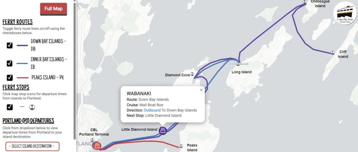
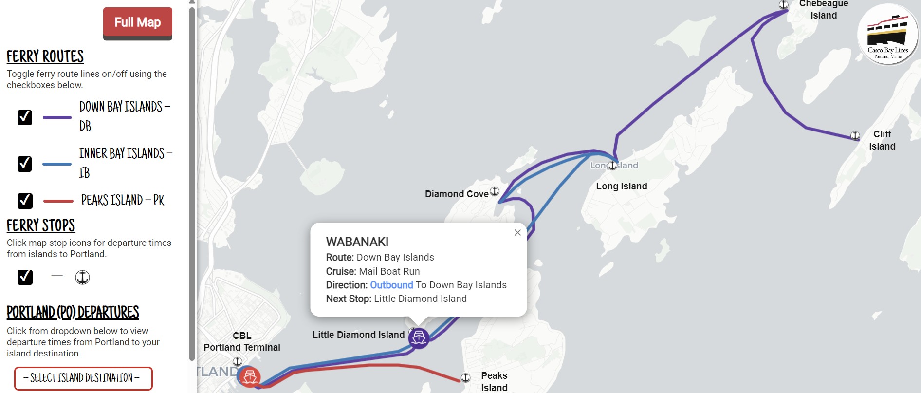
At its core, the CBL Live Map is a real-time, browser-based tracking system that allows passengers to monitor the precise geographic locations and movements of Casco Bay Lines ferries at any given moment. Refreshed continuously every 15 to 30 seconds, the interactive map offers an immediate, user-friendly interface designed to streamline trip planning, eliminate travel anxiety, and keep riders informed of critical service updates.

Since its unheralded rollout during the autumn months, the tool has drawn immediate praise from daily commuters and occasional travelers alike. Early adopters have taken to the agency’s online feedback channels to express their approval, with one commuter writing: "Your new live map is absolutely awesome and works with ease. Good job."
The launch of the CBL Live Map is much more than a convenient gadget for smartphone users; it represents the culmination of a months-long, highly strategic modernization initiative. By harnessing federal transit grants, partnering with specialized project management professionals, and deploying cutting-edge cloud software, Casco Bay Lines has overhauled its entire back-end data architecture. The result is a seamless digital ecosystem that not only powers the live map but also integrates transit data into mainstream navigation platforms like Google Maps, Apple Maps, and the Transit app.
For an agency striving to balance operational efficiency with exceptional customer service, the live map represents a monumental leap forward—reducing administrative friction, empowering passengers with actionable intelligence, and laying a robust foundation for future technological innovations.
Detailed Chronology: From Concept to Coastal Reality
The journey toward a modernized digital tracking system did not happen overnight. It was the result of a deliberate, multi-phase project timeline that began in earnest during the summer of 2024, driven by strategic planning, federal funding acquisition, and collaborative private-public partnerships.
Securing the Vision and Funding
The intellectual and financial groundwork for the CBL Live Map was laid long before the first line of code was written. The project was made possible through capital secured via the Federal Transit Administration (FTA) Section 5307 Urbanized Area Formula funds specifically designated for the Portland region. These federal funds were suballocated to Casco Bay Lines explicitly for Intelligent Transportation Systems (ITS) upgrades, supplemented by a mandatory 20% local financial match. Recognizing the pressing need to replace legacy communication methods with modern, data-driven solutions, CBL leadership prioritized the project to address long-standing passenger queries regarding vessel locations and schedules.
The July 2024 Kickoff and Strategic Partnerships
In July 2024, the initiative shifted from planning to execution. Casco Bay Lines entered a strategic partnership with Maine-based Pine Tree Project Management Pros, LLC, entrusting the local firm to oversee the complex operational rollout.
To build a reliable digital framework, CBL procured two industry-leading cloud platforms:
- Remix by Via: This platform was implemented to ingest Casco Bay Lines’ intricate seasonal and daily sailing schedules and format them into the General Transit Feed Specification (GTFS), the global standard for public transportation data.
- Swiftly, Inc.: This system was integrated to capture raw onboard GPS telemetry data from the ferry fleet and convert it in real time into GTFS-Realtime feeds.
By marrying Remix’s schedule formatting capabilities with Swiftly’s real-time vehicle tracking, CBL established a powerful, synchronized engine capable of broadcasting accurate vessel locations, scheduled departures, and emergency service advisories instantly.
The Autumn Soft Launch and Public Reception
Rather than rolling out the technology with a disruptive fanfare, Casco Bay Lines opted for a quiet, phased soft launch during the fall of 2024. This measured approach allowed engineering and operations teams to stress-test the servers, monitor GPS accuracy under varying maritime weather conditions, and fine-tune the user interface based on initial telemetry.
To the delight of agency executives, the soft launch was met with near-universal acclaim. Commuters who stumbled upon the tool quickly integrated it into their morning routines, providing glowing testimonials via digital feedback forms. Buoyed by this positive reception, CBL moved forward with this month’s official public unveiling, launching a dedicated educational campaign to help passengers discover and adopt the technology.
Supporting Context & Metrics: Under the Hood of the CBL Live Map
Understanding the true value of the CBL Live Map requires looking past the colorful user interface and examining the sophisticated data architecture powering it behind the scenes.
How It Works: The GTFS Ecosystem
The backbone of the CBL Live Map relies on open data standards known as GTFS (General Transit Feed Specification) and GTFS-Realtime. Historically, public transit agencies operated on isolated, proprietary software silos. By transitioning to GTFS, Casco Bay Lines has future-proofed its communications.
Every vessel in the Casco Bay fleet is equipped with high-precision marine GPS hardware. As the ferries navigate the waters between Portland and the islands—including Peaks Island, Little Diamond Island, Great Diamond Island, Chebeague Island, Long Island, and Cliff Island—their coordinates are transmitted to Swiftly’s cloud servers every few seconds. Concurrently, Remix cross-references these live coordinates against the scheduled timetables.
This synchronization allows the map to provide three core functionalities for riders:
- Real-Time Vessel Tracking: Passengers can watch icons representing the ferries move across an interactive map of Casco Bay, updating every 15 to 30 seconds.
- Streamlined Trip Planning: Travelers departing from the Portland terminal can instantly evaluate current transit options, while island residents can quickly check return departure times back to the mainland.
- Instant Service Advisories: In the event of mechanical delays, severe weather disruptions, or schedule adjustments, CBL staff can push real-time alerts directly through the data feed to warn passengers immediately.
Beyond the Map: Omnichannel Integration
Crucially, the cloud platforms procured during this project do not serve the live map exclusively. The exact same GTFS and GTFS-Realtime data streams are exported to power multiple passenger-facing channels simultaneously. This means the real-time data is now natively integrated into:
- Google Maps and Apple Maps: Tourists and occasional visitors searching for ferry routes on their native smartphone map applications now see live arrival and departure data.
- The Transit App: A favorite app among urban and coastal commuters worldwide.
- Onsite Terminal Gate Displays: Electronic signage inside the Portland terminal now reflects accurate, up-to-the-minute departure boards, ensuring that passengers waiting in the terminal building are equally well-informed.
Operational Relief and Efficiency
The implementation of the CBL Live Map delivers profound internal benefits for Casco Bay Lines staff, particularly personnel stationed at the customer service windows and ticket counters.
Prior to the rollout, ticket office staff were inundated with routine telephone calls from anxious passengers asking predictable questions: “Where is the ferry right now?” “Is the boat running on time?” “Has the departure been canceled due to fog?”
By putting authoritative, real-time data directly into the hands of the public via smartphones and web browsers, CBL has dramatically reduced the volume of repetitive phone inquiries. This allows ticket office personnel to focus on complex ticketing issues, customer onboarding, and overall terminal safety. Furthermore, because GTFS is an open-source standard, Casco Bay Lines possesses the scalable infrastructure required to build future operational reports and administrative tools, enhancing day-to-day maritime management.
Official Statements and Accessing the Tool
Casco Bay Lines leadership has expressed immense pride in reaching this technological milestone, emphasizing that the project underscores a commitment to both heritage and innovation.
"At Casco Bay Lines we have a long and storied history, but we’re also always looking ahead to the future," agency representatives noted in the official launch announcement. "We’re excited to offer this interactive map to the community. But we want to hear from you! Do you have any feedback? Head to our feedback form and tell us what you think."
How Passengers Can Access the CBL Live Map
For riders eager to incorporate the new tracking tool into their daily routines, Casco Bay Lines has streamlined access through multiple convenient avenues:
- Direct Web Access: Users can visit the live map directly at any time by navigating to https://livemap.cascobaylines.com/.
- Official Website Navigation: First-time visitors can visit the main Casco Bay Lines website at www.cascobaylines.com, and click the dedicated "Live Map" button located on the top navigation bar.
- Mobile App Shortcut (Add to Home Screen): To make the web-based map behave just like a native mobile app, CBL has published a step-by-step guide on its website. In four simple steps, both Apple iOS and Android users can save the live map directly to their smartphone’s home screen for instantaneous, one-tap access.
Future Outlook: Charting the Course Ahead
The debut of the CBL Live Map marks a transformative chapter for Casco Bay Lines, but agency leadership views it as a beginning rather than an endpoint.
In the fast-evolving landscape of public transportation, passenger expectations for digital transparency are higher than ever. By successfully modernizing its back-end data architecture through FTA funding and cloud-based partnerships, Casco Bay Lines has proven its ability to adapt, innovate, and execute complex technical projects.
Looking forward, the open-standard nature of the GTFS framework opens up exciting possibilities for future enhancements. Future phases of technological integration could include predictive arrival algorithms powered by artificial intelligence, automated SMS notifications for specific ferry routes, and even more granular accessibility features for disabled passengers.
As the ferries continue to plow the historic, mist-shrouded waters of Casco Bay, they do so guided not only by traditional seamanship and compass bearings, but by a cutting-edge digital pulse. For the thousands of Maine residents and visitors who rely on this maritime highway every single day, the journey just got a whole lot smoother.