








PORTLAND, MAINE — For generations, the maritime arteries of Casco Bay have pulsed with the steady rhythm of ferry traffic, connecting the mainland of Portland to the vibrant island communities dotting the Gulf of Maine. While Casco Bay Lines (CBL) proudly honors a rich, storied history deeply intertwined with Maine’s coastal heritage, the transit provider is aggressively charting a course toward the future.
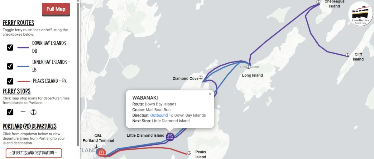
This season, CBL is officially pulling back the curtain on its most significant technological leap forward in recent memory: the CBL Live Map. Designed to bring unprecedented transparency, efficiency, and ease to daily commutes and weekend excursions alike, this state-of-the-art digital tool offers real-time vessel tracking directly to the palms of passengers’ hands.
Executive Overview: A New Era of Maritime Transit Transparency
In an era where real-time updates are standard expectations for modern transit users, Casco Bay Lines’ new interactive tracking tool bridges the gap between traditional ferry operations and cutting-edge digital infrastructure. The CBL Live Map allows riders, tourists, and daily commuters to monitor the exact geographical location of ferries traversing Casco Bay at any given second. Refreshed continuously every 15 to 30 seconds, the map transforms how passengers interact with the transit system, offering an intuitive platform to check schedules, gauge arrival times, and review critical service advisories on the fly.
Though the official, wide-scale public rollout is happening this month, a quiet soft-launch this past fall gave regular commuters an early glimpse at the technology. The response has been overwhelmingly positive. One daily commuter, taking to the CBL online feedback portal, offered a glowing endorsement of the streamlined interface: "Your new live map is absolutely awesome and works with ease. Good job."
By modernizing both front-end user experiences and back-end transit architecture, Casco Bay Lines is not only enhancing the daily passenger journey but also streamlining internal operations. The deployment of the CBL Live Map marks a transformative milestone for Maine’s public transportation network—one that promises to redefine the commuter experience across the bay.
Detailed Chronology: From Concept to Coastal Reality
The journey toward the CBL Live Map was neither accidental nor instantaneous. It represents the culmination of years of strategic planning, federal grant acquisition, technical integration, and cross-sector partnerships.
The Catalyst: Securing Federal Investment
The genesis of the project took root through targeted federal funding allocations. The initiative was made possible via the Federal Transit Administration (FTA) Section 5307 Urbanized Area Formula funds designated for the Portland region. These funds were specifically suballocated to Casco Bay Lines to finance critical Intelligent Transportation Systems (ITS) upgrades, supported by a mandatory 20% local financial match. With the funding secured, CBL laid the groundwork to bring its digital navigation capabilities into the 21st century.
Summer 2024: Project Kick-Off and Strategic Partnerships
The project began in earnest in July 2024, when Casco Bay Lines formally partnered with Pine Tree Project Management Pros, LLC, a Maine-based project management firm, to steer the complex implementation process.
To build a robust, scalable tracking system, CBL procured two industry-leading cloud platforms:
- Remix by Via: A sophisticated platform tasked with taking CBL’s intricate, seasonal sailing schedules and translating them into the globally recognized General Transit Feed Specification (GTFS) format.
- Swiftly, Inc.: A dynamic transit data platform that ingests raw onboard GPS telemetry from the ferry fleet and converts it into real-time operational feeds (GTFS-Realtime).
The Soft Launch and System Integration
Operating quietly through the autumn months, the integration of Remix and Swiftly began powering more than just a standalone web page. The modernized back-end data architecture immediately began feeding multiple passenger-facing ecosystems simultaneously. Today, the exact same high-precision data stream drives not only the dedicated CBL Live Map, but also terminal gate displays, Google Maps, Apple Maps, and the widely utilized Transit app.
By standardizing its data through open GTFS frameworks, Casco Bay Lines has ensured that its passengers can access vessel locations regardless of which third-party mapping application they prefer to use.
Supporting Context & Metrics: Transforming Operations and Passenger Experience
To fully understand the impact of the CBL Live Map, one must examine the operational realities of running a multifaceted marine transit system in Northern New England. Casco Bay Lines vessels navigate unpredictable coastal weather, heavy commercial marine traffic, and shifting tidal currents while serving thousands of residents and visitors annually.
The Power of Real-Time Data Integration
The CBL Live Map is fundamentally anchored in simplicity, accessibility, and precision. Accessible via two primary pathways, the tool is designed to cater to both tech-savvy digital natives and first-time visitors:
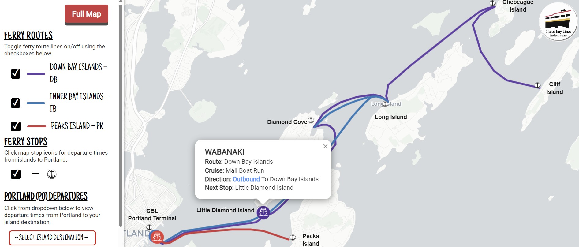
- Direct Access: Users can navigate directly to the interactive portal at https://livemap.cascobaylines.com/.
- Website Integration: Beginners can visit the main CBL website homepage, click the prominent "Live Map" button on the top navigation bar, and access a dedicated instructional landing page.
Recognizing that mobile accessibility is paramount for commuters on the move, Casco Bay Lines has provided a straightforward, four-step guide on its website allowing users to effortlessly save the live map directly to their smartphone’s home screen—fully optimized for both Apple iOS and Android devices.
Operational Relief and Efficiency Gains
Beyond enhancing the passenger experience, the technical overhaul has delivered immediate operational benefits for Casco Bay Lines staff. Historically, customer service representatives and ticket office personnel fielded a high volume of routine phone calls regarding basic inquiries: Where is the boat? Is it running on time? Are there any service delays?
With the deployment of the live map and its integration into widely used public transit apps, the frequency of these routine informational calls has dropped significantly. Passengers can now independently verify vessel status in a matter of seconds. Furthermore, because GTFS operates as an open standard, CBL’s operations team has laid the groundwork to build subsequent internal reporting tools. These emerging platforms will continue to optimize day-to-day fleet management, crew allocations, and maintenance scheduling.
Official Statements & Community Feedback
The leadership and operational teams at Casco Bay Lines have long championed a philosophy that balances maritime tradition with progressive technological adaptation. While the company’s history is anchored in decades of dependable service across the bay, leadership recognizes that meeting the modern expectations of commuters requires continuous innovation.
"At Casco Bay Lines we have a long and storied history, but we’re also always looking ahead to the future," representatives shared in the announcement of the platform. "This month, we’re excited to unveil our new tech offering, the CBL Live Map."
The focus on user-centric design was paramount during development. Rather than rolling out a complex, cumbersome enterprise software suite, CBL prioritized an interface that is functional, visually engaging, and effortlessly responsive. The map updates automatically every 15 to 30 seconds, presenting an instantaneous, interactive snapshot of maritime transit across the bay.
Yet, the rollout does not end with deployment. Casco Bay Lines has maintained an open dialogue with the community, actively encouraging riders to share their experiences and suggestions as the tool scales up.
"We’re excited to offer this interactive map to the community," project stakeholders noted. "But we want to hear from you! Do you have any feedback?" Passengers are encouraged to visit the CBL online feedback portal to submit their thoughts, ensuring the tool continues to evolve in direct response to commuter needs.
Future Outlook: Building Beyond the Map
The launch of the CBL Live Map is merely the opening chapter in Casco Bay Lines’ broader technological evolution. By successfully migrating its legacy scheduling and tracking frameworks to cloud-based GTFS and GTFS-Realtime standards, CBL has future-proofed its digital infrastructure.
As open-standard data ecosystems continue to mature, transit agencies across the country are discovering new ways to leverage real-time analytics. For Casco Bay Lines, the successful implementation of the Section 5307-funded Intelligent Transportation Systems upgrade opens the door for future expansions. Potential roadmap items include predictive arrival modeling, enhanced automated passenger counters, integrated multi-modal ticketing solutions, and advanced environmental monitoring systems across the vessel fleet.
For the residents of Peaks Island, Chebeague Island, Long Island, Cliff Island, and Great Diamond Island—as well as the countless tourists and workers who rely on the Portland waterfront daily—transit just became a little bit more predictable, and a lot more transparent. The ferries of Casco Bay will continue to sail their historic routes, guided by the timeless traditions of Maine seamanship, but they now sail proudly into the digital age.
To view the live map in action, visit livemap.cascobaylines.com. To share your feedback on the new tool, visit the Casco Bay Lines Feedback and Report Center.