








Executive Overview
For generations, Casco Bay Lines has served as the indispensable maritime lifeline for the vibrant communities dotting Maine’s Casco Bay. Operating out of the bustling Portland terminal, these iconic ferries transport thousands of daily commuters, year-round island residents, school children, and tourists across the cold, picturesque waters of the Gulf of Maine. Yet, even an institution steeped in such rich, nautical history must continuously look toward the horizon.
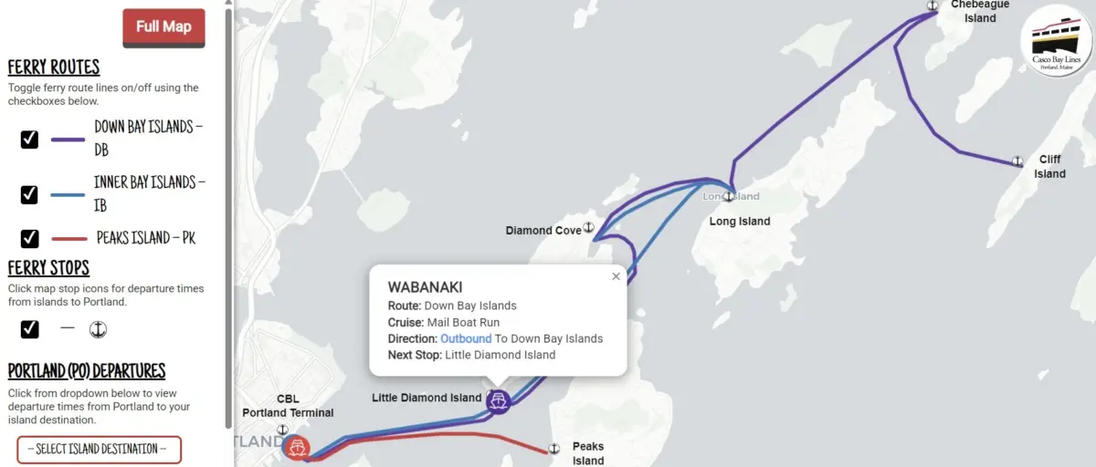
In a major leap forward for regional public transportation, Casco Bay Lines has officially launched the CBL Live Map—an innovative, real-time tracking tool designed to revolutionize how passengers interact with the ferry system. Following a quiet beta rollout earlier this fall, the tool has already earned high praise from regular commuters for its seamless interface, reliability, and ease of use.
Powered by advanced cloud-based transit platforms and funded through a strategic partnership involving federal transportation grants, the CBL Live Map provides passengers with hyper-accurate, second-by-second updates on vessel locations, departure schedules, and service alerts. Beyond merely improving the daily passenger experience, this technological overhaul modernizes Casco Bay Lines’ internal operations, paving the way for unprecedented efficiency, reduced administrative strain on ticket office staff, and enhanced integration with mainstream navigation applications like Google Maps, Apple Maps, and the Transit app.

Detailed Chronology: From Concept to Launch
The realization of the CBL Live Map was not an overnight occurrence. It represents the culmination of years of strategic planning, federal funding acquisition, and meticulous technical execution.
July 2024: The Project Begins in Earnest
While conceptual discussions regarding Intelligent Transportation Systems (ITS) upgrades had been brewing for some time, the project officially broke ground in July 2024. To ensure seamless execution, Casco Bay Lines partnered with Pine Tree Project Management Pros, LLC, a Maine-based project management firm tasked with overseeing the complex integration of modern transit software with a historic maritime operation.
Procuring the Technological Backbone
To bring real-time tracking to life, Casco Bay Lines procured two industry-leading cloud platforms:
- Remix (by Via): This platform was integrated to convert Casco Bay Lines’ intricate, seasonal sailing schedules into the standardized General Transit Feed Specification (GTFS) format.
- Swiftly, Inc.: This platform was deployed to ingest raw onboard GPS tracking data from the ferry fleet and convert it into GTFS-Realtime feeds.
By marrying these two robust cloud systems, Casco Bay Lines successfully established a modernized back end capable of broadcasting live vessel movements.
Fall 2024: Quiet Beta Launch and Community Reception
Before its official public debut, Casco Bay Lines rolled out the tool quietly during the autumn months to test system stability under real-world commuting conditions. Commuters immediately took notice of the upgrade.
Feedback poured in through the agency’s online portal, highlighting the instant utility of the map. One commuter wrote enthusiastically via the online feedback form:
"Your new live map is absolutely awesome and works with ease. Good job."
Official Public Unveiling
Building upon months of successful testing and overwhelmingly positive user reviews, Casco Bay Lines officially introduced the CBL Live Map to the broader public. The launch marks a defining milestone in the organization’s ongoing modernization efforts, signaling to riders and regional stakeholders alike that Maine’s maritime transit is ready to meet the demands of the 21st century.
Supporting Context & Mechanics: How the Technology Works
To understand the profound impact of the CBL Live Map, one must examine the underlying mechanics driving the technology. Public transit systems across the globe rely heavily on standardized data formats to communicate with consumer-facing mapping applications. By adopting GTFS and GTFS-Realtime standards, Casco Bay Lines has integrated its fleet into the global digital transit ecosystem.
Real-Time Tracking and Frequency
The CBL Live Map refreshes automatically every 15 to 30 seconds, providing an exceptionally accurate, near-instantaneous representation of vessel traffic across Casco Bay. Riders can access the map in two simple ways:
- Direct Web Link: Users can navigate directly to the dedicated web application at livemap.cascobaylines.com.
- CBL Website Homepage: Beginners can visit the main Casco Bay Lines website, click on the "Live Map" button located in the top navigation menu, and follow a simple, four-step tutorial to save the map directly to their smartphone’s home screen (compatible with both Apple iOS and Android devices).
Core Capabilities of the Map
The interactive interface is engineered to empower riders with three critical capabilities:
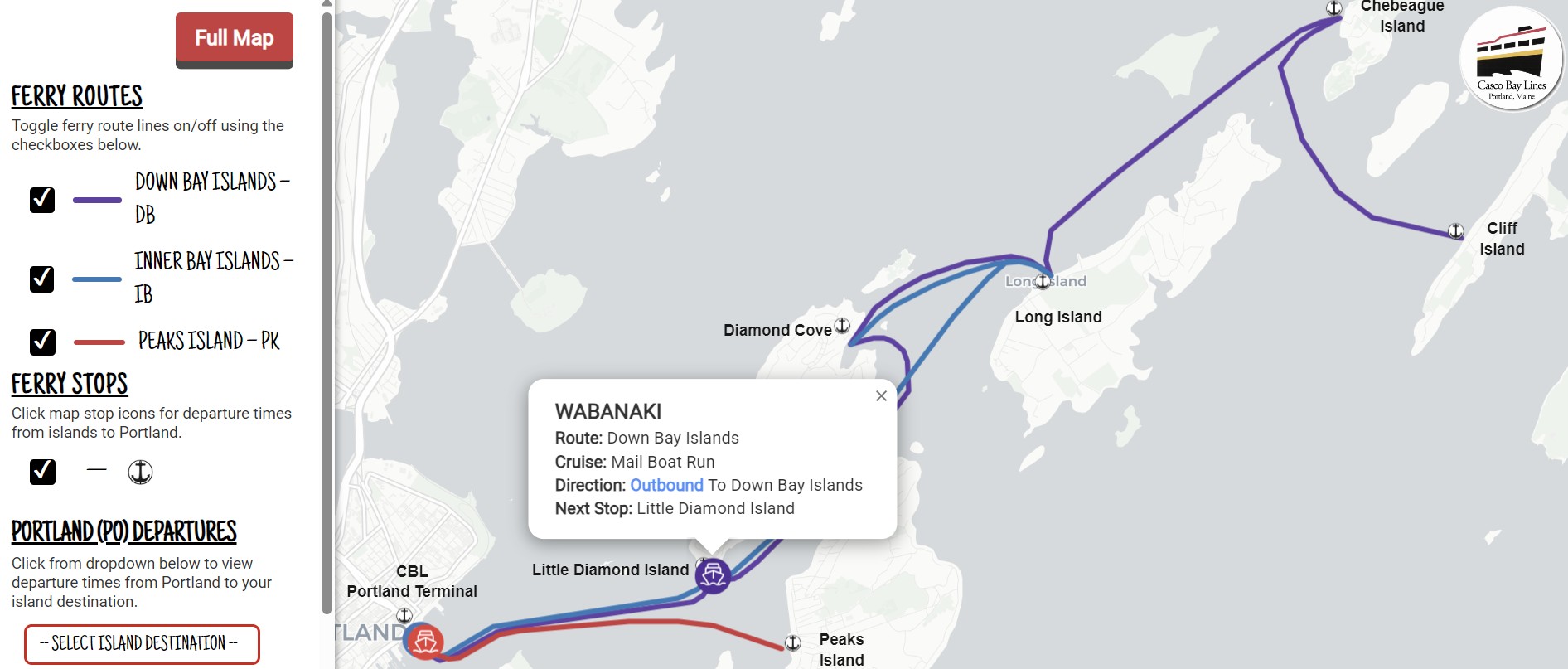
- Live Vessel Tracking: Commuters can view the exact geographic location of every active ferry traversing Casco Bay in real time, removing the guesswork from arrival and departure times.
- Seamless Trip Planning: Passengers can plan trips directly from the Portland terminal with precise timing, ensuring they make necessary connections without unnecessary waiting in the elements.
- Instant Service Alerts & Island Departures: Riders can quickly check island departure schedules for the return trip to Portland, as well as receive immediate service advisories issued directly by Casco Bay Lines staff in the event of weather delays, maintenance, or schedule changes.
Integration Across Consumer Platforms
The benefits of this technological overhaul extend far beyond Casco Bay Lines’ proprietary web map. Because the data is compiled into open GTFS standards, the exact same data feeds power:
- On-site gate displays at the Portland terminal.
- Global navigation giants including Google Maps and Apple Maps.
- Specialized transit apps such as the Transit app.
This multi-platform distribution ensures that whether a daily commuter is checking their phone at home, a tourist is navigating Portland via Google Maps, or an island resident is checking a terminal screen, the information they receive is consistent, accurate, and live.
Financial Architecture & Funding
Modernizing a historic ferry service requires substantial capital investment. The realization of the CBL Live Map was made possible through a strategic federal funding allocation paired with local matching funds.
The project was primarily funded using Federal Transit Administration (FTA) Section 5307 Urbanized Area Formula funds designated for the Portland region. These federal dollars were suballocated specifically to Casco Bay Lines for the purpose of executing vital Intelligent Transportation Systems (ITS) upgrades. To satisfy federal grant requirements, Casco Bay Lines provided a 20% local match, demonstrating the organization’s financial commitment to technological advancement and infrastructure resilience.
This funding model highlights the critical role that federal-local partnerships play in sustaining and upgrading regional public infrastructure. Without these specialized grants, the financial burden of procuring enterprise-grade cloud software like Remix and Swiftly would be significantly heavier for regional transit operators.
Official Statements & Operational Impact
The introduction of the CBL Live Map is far more than a convenience feature for tech-savvy commuters; it represents a fundamental shift in operational efficiency for Casco Bay Lines administration and crew members alike.
Alleviating Operational Strain
Prior to the implementation of GTFS-Realtime tracking, the Casco Bay Lines ticket office and customer service departments fielded a high volume of routine phone calls every single day. Passengers constantly dialed in to ask repetitive questions: Where is the ferry? Is it running on time? What time does the boat leave Peaks Island? Are there any delays?
By putting this information directly into the hands of passengers via real-time maps and integrated apps, Casco Bay Lines has dramatically reduced the volume of routine inquiry calls. Ticket office staff are now freed up to focus on complex customer service needs, ticketing operations, and terminal safety management.
Embracing Open Standards
Because the project is built upon the open GTFS data standard, Casco Bay Lines has future-proofed its technological infrastructure. Leadership notes that the agency is now positioned to build further upon these open platforms, creating bespoke tools, internal reporting dashboards, and analytical systems that will continually refine day-to-day maritime operations.
Community Voice
Casco Bay Lines has consistently emphasized that passenger feedback remains the ultimate benchmark for success. In a statement accompanying the rollout, agency representatives encouraged all regular commuters, seasonal visitors, and island residents to utilize the online feedback portal.
"We’re excited to offer this interactive map to the community. But we want to hear from you! Do you have any feedback? Head to our feedback form and tell us what you think."
Future Outlook: The Horizon of Maine Maritime Transit
As Casco Bay Lines looks toward the future, the successful deployment of the CBL Live Map establishes a strong precedent for subsequent technological integrations. In an era where passengers increasingly demand real-time transparency from every facet of public transportation, maritime operations must evolve to meet modern expectations.
The integration of advanced GPS tracking and open data standards bridges the gap between centuries-old maritime traditions and cutting-edge digital infrastructure. As Casco Bay Lines continues to analyze user data, refine its GTFS feeds, and explore additional ITS upgrades, passengers can expect an increasingly reliable, transparent, and connected travel experience across the waters of Casco Bay.
Whether braving the bitter winds of a Maine winter commute or enjoying the sun-drenched deck of a summer ferry ride, travelers navigating Casco Bay can now do so with unprecedented confidence—guided safely by the map in the palm of their hand.