











Executive Overview
Pennsylvania boasts millions of acres of strictly protected state forests, game lands, and national parks, yet the geographic footprint of Northampton County historically suffered from a distinct ecological and recreational limitation: a scarcity of substantial open-water bodies. Nestled within the picturesque, undulating topography of the Lehigh Valley—a region internationally celebrated for its industrial heritage, vibrant arts communities, and sprawling network of scenic trails—local planners recognized a missing piece in the local ecosystem. They lacked a premier aquatic playground.
To bridge this geographical gap, regional authorities orchestrated a transformative civil engineering initiative in the 1970s. By engineering a strategic dam along the East Branch of Martins Creek—a vital tributary feeding the Delaware River system within Upper Mount Bethel Township—officials intentionally flooded carefully selected acreage. The resulting endeavor birthed Minsi Lake, a sparkling 117-acre aquatic basin that now stands as the larger of only two public lakes within Northampton County.
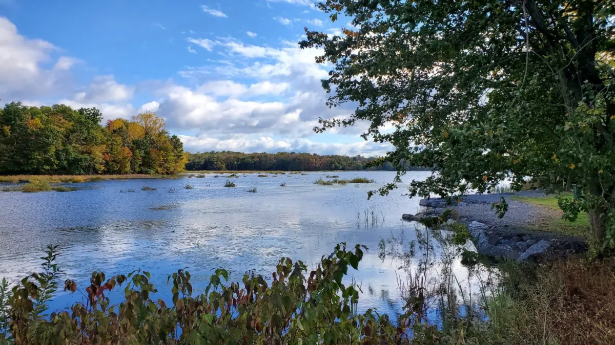
Flanked by 311 acres of lush, rehabilitated woodlands and thriving wetlands, the newly minted Minsi Lake Wilderness Area has evolved from an artificial water-storage project into a premier, multi-use outdoor haven. Located less than an hour outside of Allentown, this carefully curated landscape now welcomes thousands of visitors annually. Whether they arrive to navigate the serene waters on unpowered or electric-motor watercraft, cast lines into trout-stocked depths, or hike the 3.3-mile perimeter loop, travelers and locals alike find a masterclass in ecological restoration. This comprehensive report examines the historical timeline, structural metrics, ecological significance, regulatory frameworks, and future trajectory of one of Eastern Pennsylvania’s most compelling hidden gems.
Detailed Chronology: From Industrial Tributary to Protected Oasis
Pre-Dam Era and the Lehigh Valley Landscape
Before the mid-20th century, the rolling hills of Upper Mount Bethel Township were defined primarily by agricultural plots, dense secondary-growth forests, and the winding paths of minor watersheds. The East Branch of Martins Creek flowed largely unhindered toward the Delaware River, carving through shale and sandstone and nourishing local riparian zones. While the broader Lehigh Valley flourished as a titan of American industrialization—anchored by steel manufacturing, cement production, and bustling railway networks—the rural northern tier of Northampton County remained quiet and deeply tied to its agrarian roots.
However, as regional populations swelled and suburban development began creeping outward from Allentown, Bethlehem, and Easton, planners identified a critical deficit in public recreational infrastructure. While residents had access to terrestrial hiking paths and the Lehigh River, freshwater lake access remained severely constrained. Local stakeholders lobbied for a localized water resource that could simultaneously serve environmental conservation, flood mitigation, and public leisure objectives.
The 1970s Engineering Intervention
The turning point arrived in the 1970s when Northampton County, in coordination with state conservation agencies, initiated the Minsi Lake Dam project. Engineers selected a strategic pinch point along the East Branch of Martins Creek in Upper Mount Bethel Township to construct an earthen embankment dam.

The construction process required meticulous hydrological modeling to ensure that the impoundment would successfully capture runoff without threatening downstream communities. Upon completion, the dam halted the creek’s natural flow, inundating low-lying agricultural fields and brushlands. This deliberate flooding birthed the 117-acre Minsi Lake.
Simultaneously, recognizing that the surrounding watershed required stringent protection to prevent agricultural runoff and soil erosion from choking the new lake, county officials secured long-term lease agreements and acquisitions for the adjacent property. This land consolidation laid the groundwork for the 311-acre Minsi Lake Wilderness Area, transforming a localized civil engineering project into a sprawling regional park.
Modernization, Restoration, and Accessibility Upgrades
Decades after its initial creation, Minsi Lake underwent a significant phase of modernization to address sedimentation, shoreline erosion, and aging infrastructure. Conservation authorities emptied and rehabilitated the lakebed in the 21st century, implementing critical dam safety upgrades, dredging accumulated silt, and enhancing fish habitat structures.
Simultaneously, county planners collaborated with environmental groups to upgrade visitor amenities. Outdated dirt paths were replaced or formalized into the modern Minsi Lake Nature Trail, complete with boardwalks across sensitive wetland zones. Furthermore, engineers integrated ADA-compliant features, including an aluminum floating fishing pier equipped with step-down benches, grab bars, and a specialized kayak launch. These structural enhancements ensured that the man-made wilderness area remained accessible to all demographics, cementing its status as a cornerstone of Northampton County’s park system.
Supporting Context & Metrics: Navigating the Minsi Lake Ecosystem
To fully appreciate the scope of the Minsi Lake Wilderness Area, one must examine the precise geographical, infrastructural, and biological metrics that define this 311-acre sanctuary.
Geographic and Infrastructural Specifications
- Total Wilderness Area: 311 protected acres managed via county lease and conservation agreements.
- Surface Area of Lake: 117 acres of open freshwater, making it the larger of the two public lakes in Northampton County.
- Watershed Context: Fed primarily by the East Branch of Martins Creek, which empties into the Delaware River basin.
- Access Points: Two primary parking installations located on the eastern and western shores of the lake, both equipped with paved vehicle lots, modern restrooms, and organized picnic pavilions.
- Boating Infrastructure: Two concrete, paved boat ramps situated near the parking zones, explicitly designated for unpowered watercraft (canoes, kayaks, paddleboards) and boats utilizing electric trolling motors. Gas-powered combustion engines are strictly prohibited to preserve water quality and acoustic tranquility.
The Trail System: A Micro-Hike Metric Analysis
The terrestrial portion of the wilderness area is anchored by a cohesive trail network designed for casual hikers, birdwatchers, and families:
- The Lake Trail: Traversing the mature deciduous and evergreen woodlands along the northern shore, this segment immerses hikers in the dense forest canopy, offering glimpses of vernal pools and terrestrial wildlife.
- The Dam Trail: Hugging the engineered earthen structure on the southern perimeter, this path provides elevated vistas across the open water toward the distant ridge lines of the Lehigh Valley.
- The Minsi Lake Nature Trail Loop: By combining the Lake Trail and Dam Trail, visitors complete a seamless, easy-rated 3.3-mile loop that completely circumnavigates the shoreline. Elevation changes are minimal, making the trail accessible to novice hikers while offering enough length to provide a satisfying cardiovascular workout.
Avian and Aquatic Biodiversity
Despite its artificial origins, Minsi Lake has matured into a complex, functioning ecosystem supporting high biodiversity:
- Avian Life: The park’s protected wetlands serve as crucial stopover points along the Atlantic Flyway. Migrating species—most notably horned grebes and red-throated loons—frequent the waters during seasonal transitions. Resident populations of Canada geese and mallards utilize the reedy shallows for breeding and rearing young.
- Fisheries Management: Minsi Lake is subject to active stocking protocols administered by the Pennsylvania Fish and Boat Commission (PFBC). The waters are regularly replenished with rainbow trout, drawing anglers from across the tri-state area. In addition to trout, the lake holds robust populations of bluegill, yellow perch, and apex freshwater predators such as tiger muskies.
Official Statements and Regulatory Perspectives
The ongoing success and preservation of the Minsi Lake Wilderness Area depend heavily on inter-agency cooperation, adherence to state environmental codes, and community stewardship.
County and Conservation Authorities
Local municipal leaders have consistently emphasized that Minsi Lake represents a delicate balance between public recreation and ecological stewardship. During the park’s multi-million-dollar rehabilitation phases, Northampton County executive leadership issued statements underscoring the necessity of modernizing infrastructure without compromising the natural aesthetic.
"Minsi Lake is a testament to what regional foresight can achieve," noted local parks management officials in policy briefs regarding the site’s revitalization. "What began as a calculated hydrological modification has matured into a vital ecological anchor for Upper Mount Bethel Township. Our primary mandate is ensuring that public access—whether via kayak launch, fishing pier, or hiking trail—coexists harmoniously with the wildlife habitats we have sworn to protect."
Regulatory Compliance and Angling Oversight
The Pennsylvania Fish and Boat Commission (PFBC) maintains strict regulatory authority over the aquatic resources of Minsi Lake. Because the lake is intensively managed and regularly stocked with game fish, state authorities enforce rigorous compliance standards.
- Licensing Mandates: In accordance with Commonwealth law, all anglers aged 16 and older must possess a valid Pennsylvania fishing license, accompanied by any applicable trout permits, to legally harvest or catch-and-release species within the lake.
- Vessel Regulations: To protect the fragile benthic zones and prevent shoreline erosion, watercraft usage is legally restricted to non-motorized vessels (kayaks, canoes, rowboats) and boats propelled exclusively by electric trolling motors. Combustion engines are banned to eliminate hydrocarbon pollution and acoustic disturbance, preserving the wilderness ambiance for both wildlife and human visitors.
Future Outlook: Sustainability, Accessibility, and Regional Tourism
As the Lehigh Valley continues to experience rapid demographic growth and suburban expansion, the role of protected green spaces like the Minsi Lake Wilderness Area becomes increasingly critical. Looking toward the horizon, regional planners, conservationists, and tourism boards are aligning strategies to ensure the park thrives for generations to come.
Ecotourism and Regional Connectivity
Situated less than an hour outside of Allentown—a thriving, culturally vibrant Pennsylvania city celebrated for its culinary scene, arts districts, and economic revitalization—Minsi Lake is uniquely positioned to capture the burgeoning ecotourism market.
Travelers arriving via the Lehigh Valley International Airport (ABE), located just 26 miles southwest and offering nonstop flights from over a dozen major domestic hubs, frequently seek out rural escapes to balance their urban itineraries. Even international travelers utilizing Newark Liberty International Airport (EWR)—situated approximately 70 miles to the east—routinely make the drive westward into Northampton County to experience the scenic topography of the Poconos-Lehigh borderlands. Regional tourism boards are actively marketing the Minsi Lake Nature Trail as an essential stop on the Lehigh Valley outdoor recreation circuit, pairing wilderness hikes with visits to nearby historic small towns.
Long-Term Environmental and Climate Resiliency
Looking forward, park management faces the dual challenges of managing increased visitor volume and mitigating the impacts of localized climate volatility. Increased frequency of intense storm events poses erosion risks to the Minsi Lake Dam and surrounding trails. Consequently, future capital improvement plans involve implementing advanced green infrastructure, such as bioswales and native riparian buffer plantings, to absorb stormwater runoff naturally.
Furthermore, conservation groups are partnering with local academic institutions to monitor water quality metrics, tracking temperature fluctuations, dissolved oxygen levels, and nutrient loading to protect the stocked trout fisheries from warming water columns. Through continuous monitoring, strict regulatory enforcement, and a steadfast commitment to accessible outdoor recreation, Minsi Lake stands ready to serve as a shining model of anthropogenic environmental harmony for decades to come.