





Executive Overview
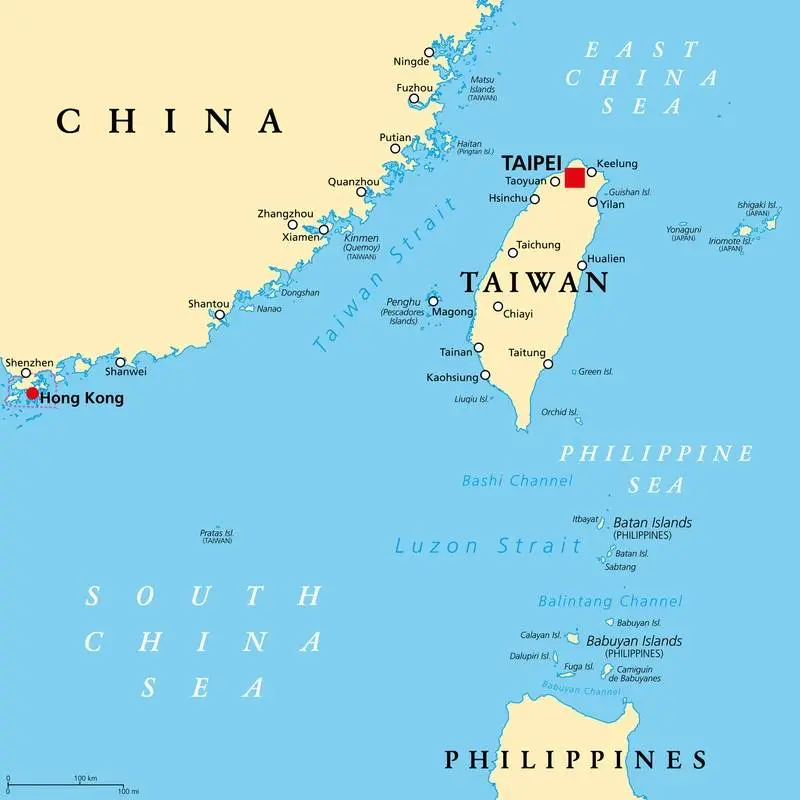
In a calculated expansion of its "grey-zone" tactics, the People’s Republic of China (PRC) has initiated a systematic maritime campaign in the waters east of Taiwan. This campaign combines scientific seabed mapping with aggressive law enforcement patrols to establish a precedent of administrative jurisdiction over the region. Over the course of August 2024, China’s Ministry of Natural Resources conducted a comprehensive three-week geological survey in the Pacific waters bordering Taiwan’s eastern coast. According to Beijing, this initiative is designed to construct a unified "one map" for national territorial planning and resource management. Concurrently, the China Coast Guard (CCG) has intensified its operational footprint in these same waters, executing its third major "routine" patrol since June.
These maneuvers represent a significant tactical shift. While historical cross-strait tensions have centered on the narrow Taiwan Strait to the west, Beijing is increasingly focusing on the deep-water Pacific frontier to the east. This shift serves a dual purpose: it aims to project sovereign jurisdiction over Taiwan’s maritime boundaries and to map underwater topography critical for submarine warfare.
The government in Taipei has reacted with sharp condemnation. Taiwan’s Coast Guard Administration (CGA) and Mainland Affairs Council (MAC) have characterized these activities as "malicious political manipulation" and "maritime provocation." They argue that these actions are designed to erode Taiwan’s sovereignty and unilaterally alter the regional status quo. As Beijing seeks to normalize its administrative and military presence on all sides of the island, international observers warn of a heightened risk of miscalculation in some of the world’s most sensitive maritime corridors.
Detailed Chronology of Maritime Encroachment
The escalation in the waters east of Taiwan throughout the summer of 2024 is not an isolated incident, but rather a coordinated, multi-agency campaign executed by Beijing. Below is a detailed timeline of the events that transpired between May and September 2024, illustrating how scientific research, law enforcement, and military posturing have been integrated.
[May 2024] ────────────────> [June 2024] ─────────────────> [Aug 10-31, 2024] ──────────> [Aug 21, 2024] ───────────> [Late Aug / Sep]
Inauguration of              CCG begins "routine"         Ministry of Natural           Taiwan CGA intercepts       CCG conducts 3rd major
Pres. Lai; Chinese           law enforcement              Resources conducts            Chinese research vessel     patrol; MAC releases
naval/air activity           patrols east of              geological seabed             sailing in sensitive        poll on public
intensifies.                 Taiwan.                      survey.                       waters.                     condemnation.
May 2024: The Strategic Catalyst
Following the inauguration of Taiwan’s President Lai Ching-te, whom Beijing labels a "separatist," the People’s Liberation Army (PLA) conducted large-scale military exercises surrounding the island. This period marked the beginning of a sustained increase in Chinese state vessels operating in the waters off Taiwan’s east coast. It set the stage for civilian and paramilitary agencies to follow.
June 2024: Normalizing the Coast Guard Footprint
The China Coast Guard initiated its first formal "routine law enforcement patrol" in the waters east of Taiwan. This move was designed to signal that Beijing views these waters not as international passages or Taiwan’s Exclusive Economic Zone (EEZ), but as domestic waters under PRC jurisdiction. A second patrol followed shortly after, establishing a bi-monthly operational tempo.
August 10–31, 2024: The Seabed Mapping Campaign
Over a 21-day period, the Ministry of Natural Resources deployed specialized research vessels to the eastern maritime sector. According to state broadcaster CCTV, the survey successfully mapped the "basic geology and structural characteristics of the seabed in China’s jurisdictional sea areas." This operation collected bathymetric, seismic, and magnetometric data under the guise of creating "one map" for resource management.
August 21, 2024: Confrontation at Sea
During the ongoing geological survey, a Chinese marine research vessel ventured into highly sensitive waters close to Taiwan’s contiguous zone. Taiwan’s Coast Guard scrambled patrol assets to shadow, warn off, and monitor the vessel. This marked the third time since May that this specific research ship had been intercepted in Taiwan’s adjacent waters. Taipei officially labeled the encounter an act of "ongoing maritime provocation."
Late August to September 2024: Institutionalizing the "New Normal"
On the heels of the completed survey, the CCG launched its third routine patrol east of Taiwan. On September 5, 2024, state media and the CCG confirmed the patrol’s completion, asserting that it successfully enforced "domestic maritime law" in the area. Taipei responded with real-time monitoring and issued strong diplomatic and public statements condemning the operations.
Supporting Context & Strategic Metrics
To understand the gravity of China’s recent maneuvers, it is necessary to examine the geographic, legal, and military dimensions of the waters east of Taiwan.
The Geography of Submarine Warfare
The Taiwan Strait, separating the island from the Chinese mainland, is shallow, with an average depth of only 60 meters. This environment is highly challenging for submarine operations due to sonar reflection and easy aerial detection.
In contrast, the waters off Taiwan’s east coast drop precipitously into the Pacific Ocean, reaching depths of several thousand meters in the Ryukyu Trench and the Philippine Sea. This deep-water environment is highly strategic:
- Submarine Corridors: Deep waters allow nuclear-powered ballistic missile submarines (SSBNs) and attack submarines (SSNs) to operate with high stealth.
- Acoustic Mapping: Gathering precise data on seabed topography, salinity, temperature gradients, and currents is essential for submarine sonar calibration and navigation.
- Anti-Submarine Warfare (ASW): By mapping these waters, the PRC improves its ability to detect American, Japanese, and Taiwanese submarines while hiding its own vessels.
| Maritime Zone | Average Depth | Primary Strategic Value | Key Operational Assets |
|---|---|---|---|
| Taiwan Strait (West) | 60 meters | Amphibious transit, surface denial, shallow mining | Fast attack crafts, littoral corvettes, maritime militia |
| East of Taiwan (Pacific) | 3,000+ meters | Deep-water submarine operations, carrier battle group maneuvers, power projection | SSNs/SSBNs, oceanographic research vessels, destroyer fleets |
The "One Map" Initiative and Cartographic Warfare
The Ministry of Natural Resources’ reference to creating "one map" (一张图) is a key element of Beijing’s "cartographic warfare." By integrating civilian oceanographic data into a centralized national database, China aims to accomplish two main goals:
- Administrative Normalization: Generating official domestic maps that include Taiwan’s eastern waters as "domestic jurisdictional seas" helps Beijing build a legalistic claim over the area. This mirrors its actions in the South China Sea, where domestic administrative designations preceded physical fortification.
- Resource Assertions: The survey targets potential deep-sea mineral deposits and methane hydrates. By claiming sole rights to survey these resources, Beijing seeks to deny Taiwan its rights under the United Nations Convention on the Law of the Sea (UNCLOS).
Grey-Zone Coercion: Substituting the Navy with the Coast Guard
By utilizing the Coast Guard and civilian research vessels instead of PLAN warships, Beijing employs "grey-zone" tactics—coercive actions that remain below the threshold of open military conflict.
This approach complicates Taiwan’s defense strategy. Responding with military warships to a civilian research vessel or a coast guard patrol risks making Taiwan appear as the escalator. Conversely, failing to respond allows Beijing to establish a "new normal" of administrative control.
Official Statements and Public Backlash
The escalation has triggered a war of words between Beijing and Taipei, highlighting their fundamentally irreconcilable views on sovereignty and maritime jurisdiction.
The View from Beijing: Domestic Jurisdiction
State media, acting as a proxy for the Chinese leadership, framed both the scientific survey and the CCG patrols as routine administrative tasks within Chinese territory. Following the September patrols, China’s state broadcaster CCTV reported:
"The routine law enforcement patrols conducted by the China Coast Guard in the waters east of Taiwan are legitimate actions to safeguard national sovereignty and maritime rights. These activities help construct ‘one map’ for territorial planning and resource management, ensuring the rule of law across all jurisdictional waters."
Beijing’s legal framework operates on the premise that because Taiwan is an inalienable part of China, the waters surrounding the island fall under the sole jurisdiction of the PRC. Consequently, any international or Taiwanese claims of an Exclusive Economic Zone (EEZ) or contiguous zone in these waters are rejected by Beijing.
The View from Taipei: Condemnation and Democratic Resilience
Taiwan’s Coast Guard Administration issued a swift and firm response, asserting its de facto control and rejecting China’s legal claims:
"We have closely monitored the Chinese operations and successfully defended our sovereignty. China has no jurisdiction over the waters surrounding Taiwan. We strongly condemn these actions, which seek to harass our maritime activities while maliciously engaging in political manipulation."
The political implications of these maneuvers were addressed during a press conference by Liang Wen-chieh, the spokesman for Taiwan’s Mainland Affairs Council (MAC). Liang presented the results of a public opinion poll conducted in August 2024, revealing deep resentment among the Taiwanese public toward Beijing’s actions.
Taiwanese Public Opinion on Chinese Patrols (August 2024 Poll):
┌────────────────────────────────────────────────────────┐
│ [████████████████████████████████████████████] 88%      │ -> View patrols as "Malicious"
│ [████] 12%                                             │ -> Undecided / Other
└────────────────────────────────────────────────────────┘
Spokesman Liang challenged Beijing’s narrative that its maritime operations are meant to protect Taiwanese interests:
"When the Chinese communists do these things, they always claim it’s to legally protect Taiwanese citizens’ rights and interests, or something along those lines. But from the perspective of the Taiwanese public, clearly you are not protecting us. The vast majority of our citizens view these continuous patrols and surveys as malicious provocations designed to erode our free way of life."
Future Outlook and Regional Implications
As Beijing continues to expand its maritime operations, the waters east of Taiwan are emerging as a major flashpoint in the Indo-Pacific. Several key trends are likely to shape the security environment in the near to medium term.
1. The Normalization of Multi-Agency Operations
The coordination between the Ministry of Natural Resources, the China Coast Guard, and the People’s Liberation Army Navy is expected to become more frequent. Future surveys will likely expand further into the Western Pacific, encroaching on the waters between Taiwan and Japan’s southwestern islands (such as Yonaguni and Ishigaki). This raises the risk of accidental encounters not only with Taiwanese forces but also with the Japanese Coast Guard.
2. Legal Warfare (Lawfare) and Enforcing Domestic Law
Analysts expect the CCG to eventually attempt to board, inspect, or detain foreign or Taiwanese fishing and commercial vessels in the waters east of Taiwan, citing domestic Chinese maritime laws. This would mirror actions taken by the CCG in the South China Sea and around the Kinmen Islands. Such an escalation would force Taiwan to decide between accepting Beijing’s jurisdiction or deploying its own assets to intervene, which could lead to a direct confrontation.
3. Internationalizing the Dispute
In response to Beijing’s pressure, Taiwan is expected to seek closer cooperation with international partners. This includes expanding real-time intelligence sharing with the United States and Japan regarding maritime domain awareness. The U.S. Navy and its allies are also likely to increase the frequency of their transits and joint exercises in the Philippine Sea to signal that these waters remain open, international corridors.
Ultimately, Beijing’s seabed mapping and coast guard patrols east of Taiwan are not mere administrative tasks. They are part of a coordinated strategy to encircle the island, gain a submarine warfare advantage, and establish a legal precedent of control over these waters. By turning these strategic waters into a contested zone, Beijing is testing the resolve of both Taipei and the international community. This dynamic ensures that the Pacific waters east of Taiwan will remain central to the ongoing geopolitical competition in the Indo-Pacific.