








Executive Overview
Deep within the craggy, sun-baked canyons of Northern California’s historic Gold Country lies a geographical paradox: an untamed aquatic sanctuary where blindingly bright emerald waters carve through ancient stone. Far removed from the manicured, palm-fringed coastlines of Southern California, the South Yuba River embodies the raw, unforgiving majesty of the Sierra Nevada mountain range. For most of the year, this rushing torrent is a ferocious, ice-cold hazard, entirely inaccessible to the casual visitor. Yet, during a fleeting, sun-drenched window in the peak of summer, this backcountry waterway transforms into one of the most sought-after swimming destinations in the American West.
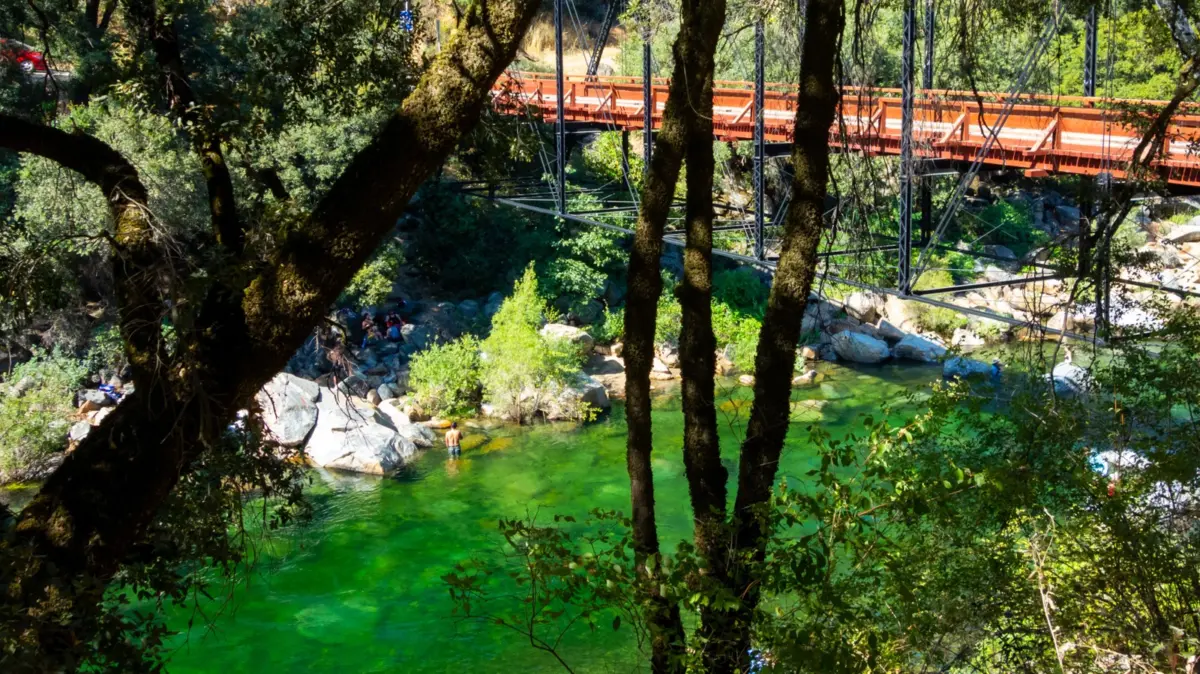
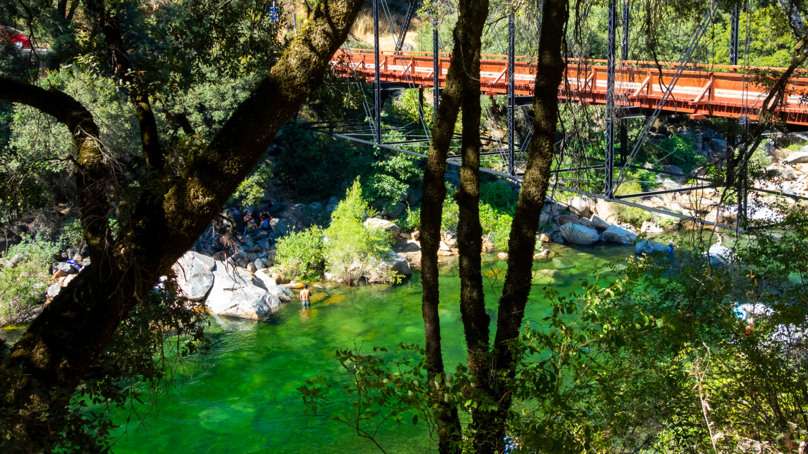
At the epicenter of this seasonal migration is Purdon Crossing, a historic metal bridge situated roughly 25 minutes outside the Victorian-era settlement of Nevada City. While neighboring swimming holes like Hoyt’s Crossing have groaned under the weight of modern over-tourism, parking crises, and municipal shuttle interventions, Purdon Crossing retains an air of remote exclusivity. Reached via a bone-jarring stretch of unpaved gravel road, it demands effort from those who seek it. Visitors are rewarded with crystal-clear alpine water, monumental sunbathing boulders, and a rugged, bohemian culture entirely divorced from commercialized beach resorts.
However, this idyllic backcountry paradise is not without its perils. The South Yuba River is a dynamic, high-consequence natural environment lacking lifeguards, cellular connectivity, and modern amenities. Navigating Purdon Crossing requires a delicate balance of deep respect for seasonal hydrology, rigorous safety protocols, and an adventurous spirit. Beyond the swimming holes, the location serves as a critical nexus for backcountry trail systems, including the grueling 20-mile South Yuba Trail and ascents toward Round Mountain ridge. This comprehensive investigation explores the geological allure, critical safety metrics, historical context, and evolving management challenges surrounding one of California’s best-kept aquatic secrets.
Detailed Chronology and Seasonal Transformation
The narrative of Purdon Crossing is inextricably linked to the dramatic seasonal rhythms of the Sierra Nevada. To understand the destination is to understand how a single geographic coordinate can morph from a deadly, raging torrent into a tranquil swimming oasis over the span of a few months.
The Spring Thaw: A Hydroelectric Hazard (April – June)
As winter yields to spring, the heavy snowpack accumulated across the high elevations of the Tahoe National Forest begins to melt. Gravity pulls billions of gallons of frigid water down through the granite arteries of the South Yuba River basin. During April, May, and early June, Purdon Crossing is an absolute no-go zone for recreationalists.
The river swells exponentially, transforming into a violent, churning rapid of ice-melt that regularly sweeps away unprepared explorers. The raw force of the water during this window is underlined by stark, unyielding municipal signage posted throughout South Yuba River State Park: “Stay Out, Stay Alive.” Hydraulic undertows, invisible underwater strainers, and near-freezing temperatures render human survival unlikely for anyone unfortunate enough to fall in. Local authorities and park rangers treat this period as an ongoing public safety emergency, deploying warnings across regional media outlets to deter thrill-seekers.
The Mid-to-Late Summer Window (July – September)
By mid-summer, the aggressive snowmelt subsides significantly. The river’s flow rate drops to manageable levels, and the ambient California heat warms the shallow pools trapped between granite boulders. This opens a narrow, highly coveted window—typically running from July through September—when Purdon Crossing becomes viable for swimming.
During these months, the transformation is staggering. The water shifts from a muddy, churning brown to a transparent, luminous emerald green. Sunbathers scale the massive river stones, and hikers shed their layers after navigating the dusty paths leading down to the water. This is when the destination reaches peak visitation, drawing hundreds of thousands of nature lovers, local residents, and travelers looking to escape the stifling central valley heat.
However, this transition from winter hazard to summer sanctuary breeds a false sense of security. The water may look inviting, but the underlying hydrology remains deceptive. Even in August, hidden currents can overpower weak swimmers, making vigilance an absolute prerequisite for anyone stepping foot into the Yuba.
Supporting Context, Geology, and Metrics
To fully appreciate Purdon Crossing, one must examine the metrics, geography, and cultural nuances that define the experience. It is a destination defined as much by its physical constraints as by its natural beauty.
Geographic and Logistical Metrics
- Location: Approximately 5.5 miles outside Nevada City, California, nestled within the South Yuba River State Park boundaries.
- Access Route: Paved asphalt transitions to roughly 5.5 miles of rugged gravel road, demanding high-clearance vehicles or cautious driving to avoid tire damage.
- Parking Capacity: Severely limited. Visitors arriving past mid-morning during summer weekends routinely face parking violations or are forced to turn away due to lack of space.
- Elevation Profile: Situated within the lower canyon slopes of the Sierra Nevada foothills, acting as a gateway to high-elevation terrain reaching up into the Tahoe National Forest.
The Hydrological Metric: Understanding Flow Rates
For those determined to swim at Purdon Crossing, relying on visual inspection alone can be fatal. River safety experts utilize objective, real-time data metrics to determine viability. Water flow rates are tracked meticulously via platforms like Dreamflows.
According to regional safety benchmarks provided by local travel advisories, a flow rate under 100 cubic feet per second (cfs) generally indicates that calm, shallow areas along the river are stable enough for cautious swimming. Anything significantly above this threshold introduces swift-water dynamics that make swimming exceedingly hazardous, even for seasoned aquatic athletes.
Cultural Atmosphere and Visitor Demographics
Purdon Crossing operates under a distinct subculture shaped by its relative isolation. Unlike family-centric public beaches equipped with restrooms, concession stands, and lifeguards, Purdon Crossing is a raw, pack-it-in-pack-it-out environment.
Furthermore, the destination has long embraced a relaxed, adult-oriented atmosphere, which occasionally includes a legacy of clothes-optional sunbathing along the more secluded granite slabs. While unstaffed and unregulated regarding dress codes, families seeking a tamer, more amenity-rich environment are routinely redirected by park rangers to alternative locations within the state park system, such as the sandy shores of Family Beach.
Official Guidelines and Safety Protocols
Because South Yuba River State Park operates as a protected yet largely untamed natural resource, administrative oversight is decentralized. There are no gatekeepers checking permits at the bridge, no permanent lifeguard towers, and no emergency medical stations on immediate standby. Consequently, visitor safety relies entirely on individual preparedness and adherence to established protocols.
The Ranger’s Code for River Safety
The management and park ranger affiliates of the South Yuba River consistently emphasize a zero-tolerance approach to reckless aquatic behavior. Official safety guidelines dictate the following protocols:
- Scout Before You Dip: Visitors must physically inspect potential swimming pools for hidden currents, back-eddies, and underwater obstructions before entering the water. Even a modest, seemingly harmless current can pin a swimmer against submerged boulders when combined with cold-water shock.
- Never Swim Alone: The remote nature of Purdon Crossing means cellular service is spotty to nonexistent. Swimming solo removes any immediate line of defense in the event of cramping, panic, or sudden exhaustion.
- Monitor Real-Time Data: Always cross-reference the day’s conditions with hydrological tracking tools like Dreamflows to ensure the river is operating below safety thresholds.
- Recognize Cold-Water Shock: Even in July, Sierra snowmelt maintains a chilling baseline temperature. Sudden immersion can cause involuntary gasping, hyperventilation, and rapid cardiac stress. Acclimatize slowly rather than diving headfirst into deep pools.
Trail Systems and Wilderness Exploration
While swimming serves as the primary draw for summer visitors, Purdon Crossing is equally renowned as a logistical anchor for some of the most dynamic hiking trails in Northern California’s foothill and mountain transition zones.
1. The South Yuba Trail (End-to-End & Segment Routes)
The crown jewel of the area’s trail network is the sprawling South Yuba Trail, a grueling roughly 20-mile path stretching from the rugged confines of the Tahoe National Forest down to Purdon Crossing.
- The Terrain: Outdoor authorities note that the trail cuts mercilessly through the rocky cliffs and steep bluffs of the river canyon. It winds continuously up, down, and around uneven terrain, offering very little flat ground. Hikers must remain vigilant against environmental hazards, notably pervasive patches of poison oak encroaching upon narrow paths.
- The Purdon-to-Edwards Crossing Segment: For those not wishing to tackle the entire 20-mile odyssey, a heavily shaded, highly scenic 5-mile (one-way) stretch connects Purdon Crossing to Edwards Crossing. This route winds past fern-lined seasonal streams, complex rock formations, and dense pockets of mixed-conifer forest. While many hikers choose to begin this leg at Edwards Crossing—benefiting from a fully paved access road—launching from Purdon Crossing offers an equally immersive wilderness experience.
2. The Round Mountain Ridge Ascent
For explorers seeking vertical challenge and panoramic vistas, Purdon Crossing acts as the starting portal to the Round Mountain Trail.
- The Route: Hikers follow the South Yuba Trail until it intersects with the Round Mountain spur.
- The Metrics: Spanning approximately 8 miles round-trip, this trek features a demanding elevation gain of roughly 1,600 feet. The trail winds upward through dense timber stands, ultimately terminating near the Round Mountain ridge. While trail reviewers on platforms like AllTrails characterize the summit view as somewhat "anticlimactic" due to heavy tree coverage obscuring sweeping horizon lines, the physical workout and quiet isolation make it a favored route for solitude-seekers.
- Alternatives: For visitors prioritizing bird-watching, botanical photography, or an easier physical footprint without steep elevation changes, nearby alternatives like the crowd-free Black Swan Trail in Smartsville provide a more leisurely Sierra Nevada experience.
Future Outlook
As urban populations in Sacramento, the San Francisco Bay Area, and regional tech hubs continue to seek out authentic outdoor recreation, destinations like Purdon Crossing face mounting pressure. The delicate balance between preserving the natural integrity of the South Yuba River ecosystem and accommodating an ever-increasing influx of summer visitors remains a central challenge for local land managers and state park authorities.
In the coming years, municipal stakeholders anticipate tighter parking regulations, potential implementation of formalized shuttle systems similar to those deployed at neighboring crossings, and enhanced digital monitoring of real-time foot traffic. Environmental groups are also pushing for expanded educational campaigns to curb trash accumulation, mitigate trail erosion, and enforce strict pack-it-in-pack-it-out ethics.
For the traveler willing to respect its boundaries, Purdon Crossing will undoubtedly remain a sacred slice of California history—a place where the roaring waters of the Sierra Nevada remind humanity of nature’s raw, unbridled power. Yet, its long-term survival as a pristine sanctuary depends entirely on the collective discipline of those who answer the call of its emerald pools.