







PORTLAND, MAINE — For generations, the maritime arteries of Casco Bay have served as the literal and figurative lifeline for the island communities dotting the coast of Maine. From daily commuters heading to the mainland for work to seasonal visitors exploring the peaks and shores of Peaks Island, Diamond Cove, and beyond, the ferries of Casco Bay Lines (CBL) are deeply woven into the regional fabric. Yet, even as a historic transit institution with a storied past stretching back well over a century, CBL has consistently kept its sights fixed on the horizon.
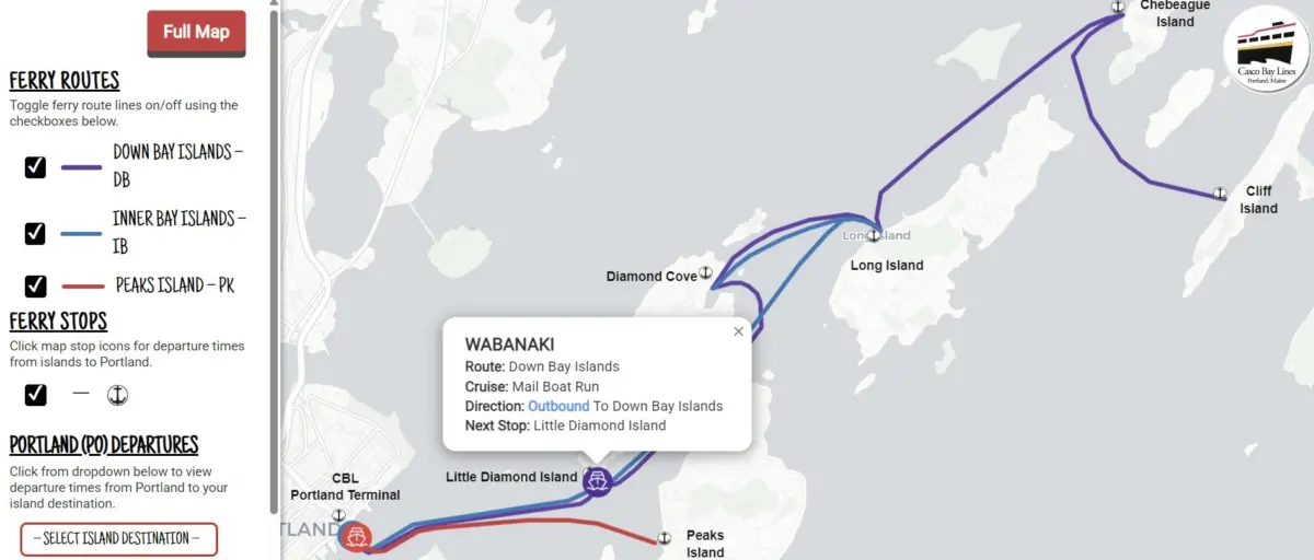
This month marks a significant technological milestone for the agency with the official rollout of the CBL Live Map—an interactive, real-time digital tracking tool designed to bring unprecedented transparency, ease, and predictability to regional ferry travel. Having quietly debuted during the fall months to test its mettle against the notoriously brisk New England weather, the tool has already captured the enthusiastic approval of daily riders.
By marrying cutting-edge cloud infrastructure with open-data transit standards, Casco Bay Lines is not merely modernizing its daily operations; it is fundamentally transforming how thousands of passengers interact with the Casco Bay transit network.
Executive Overview: A New Era of Maritime Transparency
At its core, the CBL Live Map is designed to eliminate the age-old anxieties of public transit: Where is my boat? Is it running on time? Will I make my connection?
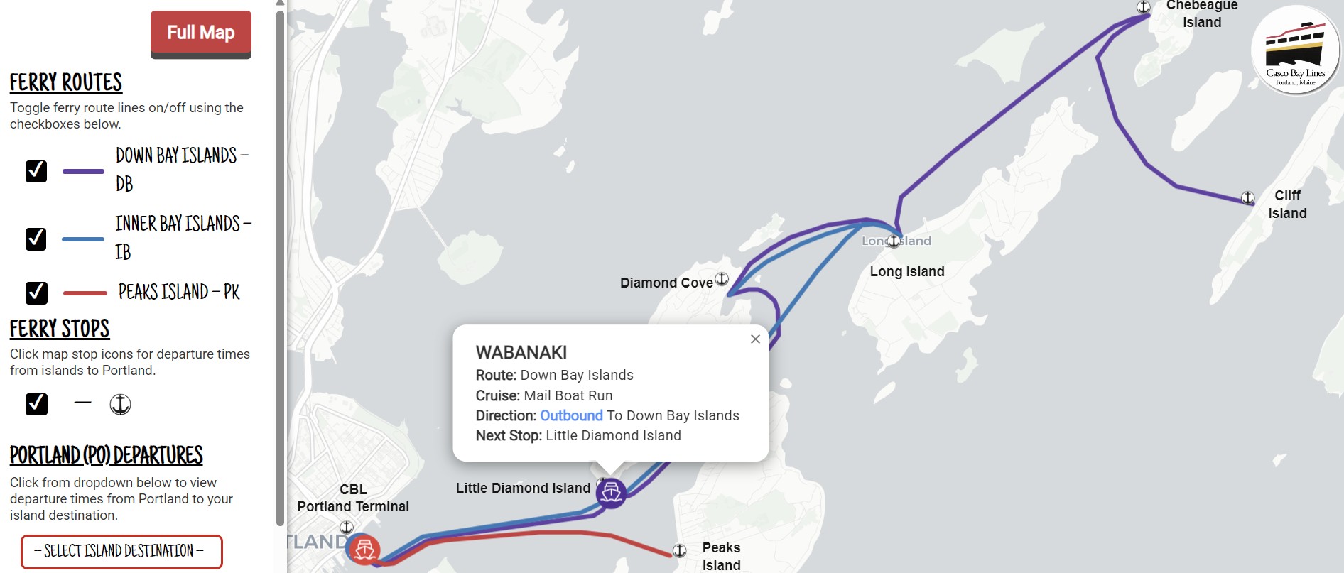
Refreshed every 15 to 30 seconds, the interactive map delivers an instant, highly responsive view of all active Casco Bay Lines vessels navigating the bay. Whether viewed through a desktop browser or pinned directly to a mobile home screen, the platform provides passengers with immediate insights into vessel locations, schedule adjustments, and critical service advisories.
The response from the community has been overwhelmingly positive. Early adopters took to the agency’s online feedback portal to voice their appreciation, with one regular commuter writing simply: "Your new live map is absolutely awesome and works with ease. Good job."
Behind this seamless user experience lies a sophisticated web of federal funding, local project management, and industry-standard transit software. By integrating advanced GPS hardware with cloud-based general transit feeds, CBL has bridged the gap between maritime tradition and digital innovation. The result is a tool that not only empowers individual passengers to take control of their schedules, but also alleviates operational burdens on terminal staff, setting a new benchmark for regional passenger vessel operations across the United States.
Detailed Chronology: From Concept to Coastal Reality
The journey toward a fully realized real-time tracking system for Casco Bay Lines did not happen overnight. It represents the culmination of years of transit planning, strategic partnerships, and technical procurement that accelerated rapidly in the summer of 2024.
The Spark: Federal Funding and Strategic Allocation
The financial foundation for the CBL Live Map was laid through federal investment. The project was made possible primarily by Federal Transit Administration (FTA) Section 5307 Urbanized Area Formula funds, specifically earmarked for the Portland region. These funds were suballocated to Casco Bay Lines explicitly for Intelligent Transportation Systems (ITS) upgrades, supported by a mandatory 20% local matching contribution.
July 2024: Project Kickoff
The initiative entered its operational execution phase in July 2024. To ensure rigorous oversight and keep the complex technical integration on track, CBL partnered with Portland-based Pine Tree Project Management Pros, LLC. Entrusted with steering the project lifecycle, the Pine Tree team coordinated between software vendors, municipal stakeholders, and internal CBL operations staff.
Procuring the Cloud Platforms
At the heart of the system are two powerful, industry-leading cloud platforms procured specifically for this initiative:
- Remix (by Via): This platform was integrated to ingest CBL’s complex, seasonal sailing schedules and format them into the globally recognized General Transit Feed Specification (GTFS). Remix serves as the static database backbone, mapping out routes, stops, and timetables.
- Swiftly, Inc.: Swiftly was brought on board to handle the dynamic side of the equation. The platform converts raw onboard GPS telemetry data from Casco Bay Lines vessels into GTFS-Realtime feeds.
By combining Remix and Swiftly, CBL established a unified data pipeline. When a vessel casts off from the Portland terminal, its physical coordinates are transmitted, processed by Swiftly, matched against scheduled times via Remix, and instantly rendered onto the CBL Live Map interface.
The Quiet Launch and Public Adoption
Following rigorous internal testing, the map was deployed in a soft launch phase during the fall of 2024. Rather than rolling out the tool with a massive promotional campaign, CBL allowed the technology to speak for itself. Commuters discovered the map organically through the agency’s website or via word-of-mouth. The strategy paid off: the tool handled peak commute loads effortlessly, earning high praise from frequent riders and ironing out minor user-interface nuances well ahead of the official public unveiling.
Supporting Context, Architecture, and Metrics
To truly appreciate the engineering feat behind the CBL Live Map, one must examine the underlying architecture that drives it. Open-data standards have revolutionized urban transit over the past decade, yet applying these standards to marine environments—where currents, weather, and open-water navigation introduce variables distinct from urban bus lines—presents unique challenges.
Powering More Than Just a Map
While the standalone CBL Live Map interface (livemap.cascobaylines.com) is the most visible manifestation of this project, the data pipeline feeds a much wider ecosystem. The exact same GTFS and GTFS-Realtime feeds power:
- Terminal gate displays at the Portland facility, keeping waiting passengers informed.
- Third-party mapping applications relied upon by millions, including Google Maps, Apple Maps, and the popular Transit app.
This multi-channel distribution means that whether a tourist is planning a trip from out of state using Apple Maps or a local island resident is checking departure times on the agency’s dedicated web portal, the underlying data remains unified, accurate, and up-to-the-minute.
Operational Metrics and Efficiency Gains
Beyond enhancing the passenger experience, the technical overhaul addresses critical operational pain points for Casco Bay Lines. Historically, the agency’s ticket office and customer service desks experienced high volumes of routine phone calls. Patrons frequently called to ask basic logistical questions: Where is the boat right now? Has the 2:15 PM departure left yet? Are there any weather delays?
By making this information universally accessible in the palm of every passenger’s hand, the CBL Live Map has dramatically reduced the frequency of routine informational calls. Ticket agents and terminal staff are now freed up to focus on complex ticketing issues, passenger safety, and vessel loading logistics.
Furthermore, because the system is built on open standards (GTFS), Casco Bay Lines has future-proofed its digital infrastructure. The agency can seamlessly build upon these platforms, introducing future tools such as predictive crowding indicators, automated delay notifications, and advanced internal analytics dashboards that will optimize daily fleet management and fuel efficiency.
Official Statements and Community Engagement
The leadership at Casco Bay Lines views the launch of the live map not as a static completion of a tech project, but as an ongoing dialogue with the communities they serve. Maintaining deep historical roots while aggressively embracing modern mobility solutions requires constant communication with the public.
Agency representatives have emphasized that the success of the soft launch belongs as much to the riders as it does to the engineering team. Passenger feedback gathered during the fall trial period directly validated the agency’s investment in the Pine Tree Project Management Pros partnership and the Via/Swiftly software stack.
In statements accompanying the rollout, CBL officials highlighted the importance of community accessibility:
"We have a long and storied history, but we’re also always looking ahead to the future. This tool is designed to make island living and commuting simpler, more transparent, and entirely stress-free. We want our riders to feel connected to the fleet from the moment they step out of their homes."
To ensure broad adoption across all demographics—from tech-savvy digital natives to older island residents—CBL designed the onboarding process to be as frictionless as possible. Visitors to the main website can access a dedicated guide complete with a short instructional video detailing how to bookmark the live map directly to an Apple or Android smartphone home screen in four simple steps.
Despite the glowing early reviews, Casco Bay Lines is refusing to rest on its laurels. The agency has explicitly invited ongoing public commentary to refine the tool further. Riders are encouraged to submit their thoughts, bug reports, or feature suggestions via the official CBL Online Feedback Form.
Future Outlook: The Next Horizon for Casco Bay Transit
As the CBL Live Map settles into its permanent role as an indispensable regional transit utility, attention naturally shifts to what lies ahead for Casco Bay Lines. The successful integration of FTA Section 5307 funding proves that regional marine transit authorities can successfully deploy sophisticated urban-style Intelligent Transportation Systems tailored to unique coastal environments.
Expanding Digital Capabilities
With the cloud infrastructure now firmly established via Remix and Swiftly, CBL is well-positioned to explore secondary and tertiary technological integrations. Future phases of the agency’s modernization roadmap could include:
- Real-time Capacity Tracking: Integrating weight-sensor or automated passenger-counting data to show riders how full a vessel is before they arrive at the gate.
- Proactive Push Notifications: Developing opt-in SMS or app-based alert systems that automatically notify registered commuters of weather-related cancellations or schedule adjustments specific to their preferred routes.
- Enhanced Environmental Monitoring: Leveraging onboard sensor networks to track weather and sea state conditions in real-time, providing both captains and dispatchers with superior situational awareness across Casco Bay’s diverse microclimates.
A Model for Coastal Transit Nationwide
As small-to-mid-sized ferry systems across North America struggle with aging infrastructure and the rising expectations of modern passengers, Casco Bay Lines’ recent success offers a compelling case study. By thoughtfully combining federal grant funding, local project management expertise, and standardized open-data architecture, CBL has demonstrated how a historic maritime operator can leap into the digital age without losing its community-centric identity.
For the residents of the Casco Bay islands and the countless travelers who journey across its storied waters every year, the message is clear: navigating the bay is now smoother, smarter, and more transparent than ever before.
To experience the tool firsthand, view active vessel locations, or learn how to save the application to your mobile device home screen, visit the CBL Live Map today.