









Executive Overview
In a metropolis defined by verticality, concrete, and the ceaseless hum of urban life, the notion of wild, untouched wilderness within New York City limits sounds like an oxymoron. Yet, tucked away on the southwestern periphery of Staten Island lies a sprawling sanctuary that defies the concrete jungle stereotype. Known colloquially as the "Forgotten Borough," Staten Island has long stood apart from its densely packed sister boroughs—Manhattan, Brooklyn, Queens, and the Bronx—in both demographic distribution and geographic separation.
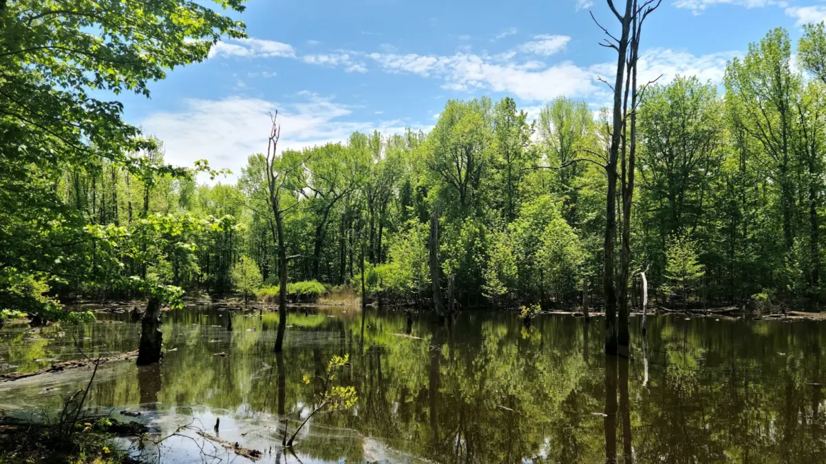
This geographic and developmental isolation, however, has yielded an unexpected ecological windfall. While the rest of New York City scrambled to monetize every square foot of available land during the real estate booms of the 20th and 21st centuries, Staten Island retained vast tracts of pristine landscape. Among the most remarkable of these protected jewels is the North Mount Loretto State Forest. Spanning acres of mixed hardwood forests, vernal pools, and delicate wetlands, this protected enclave offers a stark counter-narrative to the standard urban experience.
The story of North Mount Loretto State Forest is not merely one of accidental preservation; it is a calculated triumph of modern conservation, public-private land trust intervention, and state-level environmental stewardship. Today, the forest serves as a vital ecological corridor, a haven for native wildlife, and a restorative retreat for urbanites seeking respite from the cacophony of the city. This comprehensive report examines the history, geography, ecological significance, accessibility, and future trajectory of New York City’s most remote and remarkable public forest.
Detailed Chronology: From Remote Frontier to Protected Sanctuary
To understand how nearly 3,000 acres of natural land managed to escape the relentless march of New York City’s urban sprawl, one must trace the historical evolution of Staten Island’s southwestern shore.
Pre-Colonial and Early Settlement Eras
Long before the Dutch and English arrived in the Hudson estuary, the Lenape people inhabited the rolling hills and rich coastal wetlands of what is now Staten Island. They utilized the southwestern tip—specifically the areas surrounding modern-day Richmond Valley, Tottenville, and Charleston—for fishing, hunting, and harvesting the abundant resources of the Raritan Bay and Arthur Kill waterways.
Following European colonization, the southern tier of Staten Island remained predominantly rural for centuries. While Lower Manhattan exploded into a global commercial hub and Brooklyn rapidly urbanized, Richmond Valley retained an agrarian and maritime character. Its intricate network of tidal creeks, salt marshes, and dense forests made large-scale commercial development difficult and economically unviable for much of the 18th and 19th centuries.
The Institutional Era and Conservation Turning Points
In the late 19th and early 20th centuries, large parcels of land in the area were acquired by religious and charitable institutions looking for expansive, isolated campuses to serve institutional needs. The Roman Catholic Archdiocese of New York, for instance, established significant landholdings in the Mount Loretto area, operating facilities that utilized only a fraction of the vast acreage. The surrounding acreage remained largely undisturbed, acting as a de facto buffer zone of secondary-growth forests and wetlands.
By the late 20th century, as the Verrazzano-Narrows Bridge spurred suburban development across Staten Island, conservationists grew increasingly alarmed about the rapid loss of the borough’s natural habitats. The southwestern corner—wedged between Tottenville and Charleston—became a prime target for residential and commercial real estate speculators.
The Trust for Public Land Intervention
Recognizing the impending threat to the region’s delicate hydrology and unique ecosystems, the Trust for Public Land (TPL)—a national nonprofit dedicated to conserving land for public health and community benefit—stepped in. In a series of strategic negotiations, the TPL acquired roughly 600 acres of ecologically sensitive land in the area to shield it from encroaching suburbanization.
The acquisition marked a watershed moment for Staten Island conservation. By securing these parcels, the TPL preserved critical wetlands that act as natural sponges, mitigating storm surges and filtering runoff before it enters the Arthur Kill and Raritan Bay.
State Designation and Modern Management
The crowning achievement of these conservation efforts occurred in 2008. The New York State Department of Environmental Conservation (NYSDEC) formally designated 74 acres of the Trust for Public Land’s acquisitions as the North Mount Loretto State Forest.
This official state classification placed the property under stringent environmental protection laws, ensuring that its hardwood canopies, vernal pools, and wildlife corridors would be preserved in perpetuity. Over the subsequent decade and a half, the NYSDEC, in collaboration with local stakeholder groups and volunteers, developed low-impact recreational infrastructure, including color-coded hiking trails, information kiosks, and designated access points, transforming a previously inaccessible tract of private institutional land into an open-air classroom and public recreational asset.
Supporting Context & Metrics: Geography, Ecology, and Access
North Mount Loretto State Forest is not an isolated ecological island; it functions as part of a much larger, interconnected matrix of open space in southwestern Staten Island. Examining the hard data and geographical parameters of the forest reveals the scale of its importance to the regional ecosystem.
Geographical Boundaries and Topography
The state forest straddles Cunningham Road within the Richmond Valley neighborhood. Its boundaries interface directly with adjacent municipal and protected green spaces, including Long Pond Park to the south.
- Total State Forest Acreage: 74 acres (within a broader 600-acre conservation zone secured by the Trust for Public Land).
- Surrounding Neighborhoods: Bounded by Richmond Valley, Tottenville, and Charleston (noted for housing major residential and retirement developments such as The Tides).
- Waterways & Edges: Bordered to the west by the Arthur Kill tidal strait separating Staten Island from New Jersey, and to the south by the Raritan Bay.
- Elevation & Terrain: Generally flat to gently rolling coastal plain topography, characterized by saturated soils, seasonal vernal pools, and low-lying wetland depressions interspersed with upland forest ridges.
Flora and Fauna: Biodiversity in the Five Boroughs
Despite its urban coordinates, North Mount Loretto State Forest supports a surprisingly robust array of plant and animal species.
- Forest Canopy: The upland sections are dominated by mixed hardwood forests. Mature stands of American beech (Fagus grandifolia), white oak (Quercus alba), red oak (Quercus rubra), and sweetgum provide a dense canopy that shifts dramatically in color through the seasons.
- Understory and Wetlands: The wetland fringes and swampy depressions foster moisture-loving vegetation, ferns, and shrubs that provide critical nesting and foraging habitat.
- Avian Life: The forest and adjacent Long Pond Park serve as important stopover sites for migratory birds along the Atlantic Flyway. Visitors regularly spot red-tailed hawks, great blue herons, Canada geese, and various species of songbirds and woodpeckers.
- Herpetofauna and Mammals: The vernal pools are vital breeding grounds for amphibians, including spring peepers, wood frogs, and spotted salamanders. Meanwhile, terrestrial mammals such as white-tailed deer, raccoons, eastern cottontail rabbits, and red foxes find safe harbor within the unfragmented forest interior.
Official Statements and Stakeholder Perspectives
The preservation and ongoing management of North Mount Loretto State Forest reflect a cooperative ethos among state environmental agencies, national conservation nonprofits, and the local community.
State and Municipal Conservation Objectives
The New York State Department of Environmental Conservation emphasizes that properties like North Mount Loretto serve a dual purpose: protecting urban biodiversity while providing equitable access to nature for millions of city residents.
"State forests within urban boundaries are essential tools for climate resilience and public health," notes a regional NYSDEC land management spokesperson. "North Mount Loretto protects critical wetland infrastructure that absorbs storm water, mitigates urban heat island effects, and safeguards water quality in the Arthur Kill. At the same time, it provides an invaluable psychological and physical escape for New Yorkers who may not have the means to travel to upstate wilderness areas."
The Trust for Public Land’s Vision
For the Trust for Public Land, the acquisition and subsequent designation of the Richmond Valley acreage represented a cornerstone strategy for urban conservation. By securing 600 acres in southwestern Staten Island, the organization successfully halted a wave of high-density development that threatened to permanently sever the ecological linkages between the island’s interior forests and its coastal marshes.
Conservation planners frequently point to North Mount Loretto as a prime example of "green infrastructure networking"—proving that high-value real estate markets can still yield significant land for permanent preservation if public-private partnerships are mobilized effectively.
Community Reception and Visitor Sentiment
Local residents and recreational visitors have embraced the state forest as a peaceful sanctuary. Online visitor logs and hiking reviews consistently highlight the profound silence and isolation available within the park.
"When you step onto the trails here, the sounds of traffic and city life completely vanish," shared a frequent Staten Island hiker. "It’s hard to believe you’re still within the boundaries of New York City. It’s a raw, beautiful, and completely unpretentious piece of nature."
Future Outlook: Challenges and Preservation Strategies
As North Mount Loretto State Forest looks toward the coming decades, land managers, ecologists, and municipal planners face a unique set of challenges inherent to managing wilderness areas embedded within a sprawling metropolitan footprint.
Climate Change and Sea-Level Rise
Situated immediately adjacent to the Arthur Kill and Raritan Bay, the southwestern coast of Staten Island is highly vulnerable to the impacts of global climate change, including rising sea levels, increased frequency of severe coastal storms, and higher storm surges. While the wetlands within and around North Mount Loretto act as natural shock absorbers, protecting inland residential areas, the forest itself faces ecological stress from saltwater intrusion and shifting hydrological patterns.
NYSDEC adaptation strategies focus on maintaining the permeability of the soil, preventing upstream runoff pollution, and protecting the native vegetative buffers that anchor the coastline.
Invasive Species Management
Like many urban and suburban forests in the northeastern United States, North Mount Loretto is under constant pressure from invasive non-native species. Aggressive plant invaders—such as Japanese knotweed (Reynoutria japonica), multiflora rose (Rosa multiflora), and Oriental bittersweet (Celastrus orbiculatus)—threaten to outcompete native understory flora and disrupt forest regeneration. Furthermore, forest pests like the emerald ash borer pose ongoing threats to canopy health.
To combat these pressures, the NYSDEC, alongside volunteer stewardship groups, routinely organizes invasive species removal initiatives and monitoring programs to protect native saplings and maintain ecological balance.
Balancing Public Access with Ecological Protection
As awareness of North Mount Loretto State Forest grows, balancing increased visitor foot traffic with the imperative of habitat protection remains a delicate tightrope walk. Current infrastructure includes five short, color-coded trails originating near the Cunningham Road parking lot, including a wheelchair-accessible path and designated bike-friendly routes totaling roughly two miles. Four trails seamlessly integrate into the North Mount Loretto Blue, Red, Orange, and White Trail Loop—a 1.6-mile excursion winding through beech and oak groves and skirting the water bodies of adjacent Long Pond Park.
Maintaining this low-impact model ensures that the forest remains accessible for hikers, birdwatchers, and nature photographers without degrading the delicate wetland ecosystems that make the sanctuary so ecologically vital in the first place.
Logistical Guide: Visiting North Mount Loretto State Forest
For travelers and locals eager to experience this rare urban wilderness firsthand, reaching North Mount Loretto is remarkably straightforward, despite its remote feel.
Location and Admission
- Address / Main Entrance: Cunningham Road, Richmond Valley, Staten Island, NY 10307 (primary parking area and information kiosk located along the northern edge of the forest).
- Cost: Completely free of charge (no admission or parking fees).
- Accessibility: Features designated accessible trail segments, making it welcoming to a diverse range of visitors.
Transportation Options
- By Air: The closest major aviation hub is Newark Liberty International Airport (EWR), located approximately 20 miles to the north across the New Jersey border in Newark, NJ. EWR offers extensive domestic and international nonstop flight connections.
- Public Transit via Manhattan: Visitors can board the iconic Staten Island Ferry at the Whitehall Ferry Terminal in Lower Manhattan. The free 25-minute ferry ride offers sweeping, unobstructed views of New York Harbor and the Statue of Liberty. Upon disembarking at the St. George Ferry Terminal on Staten Island, travelers can take the Staten Island Railway (SIR) directly to the Richmond Valley station, followed by a short walk or taxi ride to the trailhead.
- By Automobile: Accessible via major Staten Island highways (such as the West Shore Expressway / Route 440 and Korean War Veterans Parkway), leading down to the Richmond Valley commercial and residential corridors.
Whether approached as a weekend birdwatching excursion, a botanical study of coastal wetlands, or simply a quiet walk beneath a canopy of ancient oaks, North Mount Loretto State Forest stands as a testament to the enduring power of conservation—proving that even in the heart of America’s densest megalopolis, wild nature can still find a way to flourish.