





Executive Overview
The global maritime industry stands at a critical juncture. Faced with tightening environmental regulations, volatile fuel markets, and the urgent imperative to decarbonize, ship owners and operators are under unprecedented pressure to maximize voyage efficiency. In response to this shifting landscape, ocean data pioneer Sofar Ocean has unveiled Wayfinder Explore, a sophisticated suite of voyage optimization tools designed specifically for fleets that manage their routing decisions in-house.
Traditionally, ship operators have had to choose between outsourcing their routing to external specialist providers or relying on internal teams equipped with fragmented, legacy tools. Wayfinder Explore disrupts this dichotomy by democratizing access to high-fidelity weather and vessel performance data. By delivering the exact same advanced meteorological models and routing algorithms utilized by Sofar’s own in-house routing experts directly to fleet managers, superintendents, and vessel masters, the platform bridges the gap between shore-side strategy and ship-board execution.
Scheduled to begin initial fleet trials in the fourth quarter of this year, Wayfinder Explore promises to redefine how maritime enterprises evaluate risk, fuel consumption, and transit times. By integrating real-time feedback loops, proprietary ocean sensor data, and machine-learning-driven vessel performance models, the platform gives captains and chartering desks the autonomy to simulate, edit, and optimize voyages in real time. In doing so, Sofar Ocean is not merely launching a software tool; it is championing a paradigm shift toward collaborative, data-driven, and autonomous maritime decision-making.
Detailed Chronology & Operational Mechanics
To understand the impact of Wayfinder Explore, it is necessary to examine the operational workflows it transforms and the timeline of its integration into the maritime ecosystem.
+-----------------------------------------------------------------------------+
|                          WAYFINDER EXPLORE WORKFLOW                         |
+-----------------------------------------------------------------------------+
|                                                                             |
|  1. DATA INGESTION                                                          |
|     [Proprietary Spotter Buoy Network] ---> [Real-time Wave & Weather Data] |
|                                                                             |
|  2. SIMULATION & MODELING                                                   |
|     [Noon Reports & Historical Data] ----> [Dynamic Vessel Twin (ML Model)] |
|                                                                             |
|  3. REAL-TIME OPTIMIZATION                                                  |
|     [One-Click Optimization] ------------> [Fuel, Speed, & Route Adjusted]  |
|                                                                             |
|  4. SHIP-SHORE COLLABORATION                                                |
|     [Instant Link Sharing] --------------> [Captain & Shore Desk Aligned]   |
|                                                                             |
|  5. AUDIT & COMPLIANCE                                                      |
|     [Full Decision History Logged] ------> [Continuous Operational Auditing]|
|                                                                             |
+-----------------------------------------------------------------------------+
The Genesis of Self-Managed Routing
For decades, maritime weather routing was a reactive discipline. Shore-based routers would send static PDF route recommendations to vessels prior to departure. If weather conditions deteriorated mid-voyage, captains had to rely on onboard radar, basic weather faxes, or wait hours for an updated recommendation from shore.
The rise of satellite connectivity (VSAT and Low-Earth Orbit constellations like Starlink) has enabled real-time data transfer, setting the stage for dynamic voyage optimization. Recognizing that a significant portion of the global fleet prefers to keep routing decisions strictly in-house to protect commercial confidentiality and maintain operational control, Sofar Ocean initiated the development of Wayfinder Explore.
Built upon Wayfinder Core—the robust foundational engine that powers Sofar’s bespoke routing services—Explore represents the productization of enterprise-grade routing intelligence. The development timeline culminates in Q4, when select global shipping lines will initiate live fleet trials, stress-testing the platform across diverse vessel types and trading routes.

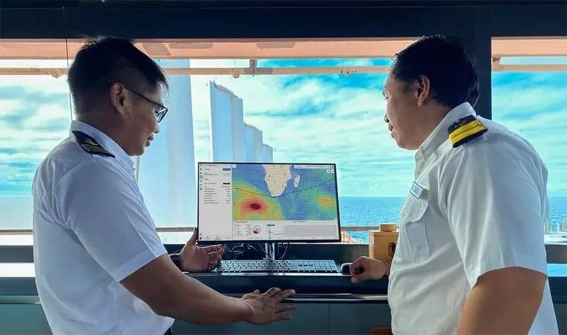
The Anatomy of a Voyage: How Explore Works in Real Time
Wayfinder Explore restructures the interaction between the vessel’s master (the Captain) and the shore-side operations desk. The operational cycle of the platform unfolds across five distinct phases:
- The Initial Plan: Upon receiving a voyage charter party, the shore routing desk or the captain inputs the departure, destination, and required time of arrival (RTA). Wayfinder Explore immediately generates an optimized baseline route designed to minimize fuel consumption while respecting the vessel’s specific safety constraints (e.g., maximum wave heights, wind speeds, and roll angles).
- Dynamic Simulation and Editing: Unlike rigid black-box solutions, Explore allows operators to manually manipulate the route. If a captain prefers to avoid a specific choke point or navigate around a localized marine sanctuary, they can drag-and-drop waypoints directly on the interactive map. Crucially, the platform also allows for the modification of engine inputs, such as RPM or power limits, on a segment-by-segment basis.
- Instant Re-Simulation: With every manual adjustment—whether moving a waypoint by five miles or reducing engine RPM by 5%—Wayfinder Explore re-simulates the entire voyage. Within seconds, the system calculates and displays the exact impact of the change on total fuel consumption, emissions, estimated time of arrival (ETA), and overall operational cost.
- Collaborative Alignment: Once a route is modified, it can be shared instantly via a secure, lightweight link. This ensures that the captain on the bridge, the technical superintendent in London, and the chartering manager in Singapore are looking at the exact same digital twin of the voyage, eliminating communication lag and reducing the risk of misunderstandings.
- Post-Voyage Auditing: After a voyage is completed, Explore maintains a meticulous digital ledger of the trip. The system archives the weather forecasts available at the time of each decision, the vessel performance models used, the alternative routes considered, and the identity of the user who authorized the final route. This transparency is critical for resolving charter party disputes and auditing carbon intensity metrics.
Supporting Context & Metrics
The efficacy of any voyage optimization tool is fundamentally limited by the quality of the data that feeds it. Wayfinder Explore distinguishes itself by leveraging Sofar Ocean’s proprietary ocean intelligence infrastructure, addressing the chronic "data deficit" that has long plagued maritime meteorology.
+-------------------------------------------------------------------------+
|                  THE SOFAR DATA ADVANTAGE BY THE NUMBERS                 |
+-------------------------------------------------------------------------+
|                                                                         |
|  [50% Wave Forecast Accuracy Improvement]                               |
|  Powered by the Spotter Network—the world's largest private ocean       |
|  sensor array, delivering peer-reviewed forecasting precision.          |
|                                                                         |
|  [2% Fuel Prediction Accuracy]                                          |
|  Dynamic machine learning vessel models retrain daily using noon        |
|  reports and local weather to accurately project fuel consumption.      |
|                                                                         |
|  [0.5 Knots Speed Prediction Accuracy]                                  |
|  Ensures highly reliable Estimated Times of Arrival (ETA) to avoid      |
|  costly port delays and demurrage fees.                                 |
|                                                                         |
+-------------------------------------------------------------------------+
The Spotter Network: Solving the Ocean Data Gap
Traditional weather models rely heavily on government satellites and sparse, stationary meteorological buoys. Satellites, while effective at capturing large-scale atmospheric patterns, often struggle to measure sea-surface dynamics—such as wave spectral energy and localized currents—with high precision. Furthermore, vast stretches of the open ocean, where commercial vessels spend the majority of their transit time, remain virtually unmonitored.
Sofar Ocean solved this problem by deploying the Spotter Network, the world’s largest private network of ocean sensors. These compact, solar-powered, drifting buoys constantly measure wave height, period, direction, wind speed, and sea surface temperature, transmitting this data via satellite in real time.
By assimilating this massive, proprietary dataset into their proprietary wave models, Sofar achieves unprecedented forecasting accuracy. Peer-reviewed research indicates that the integration of Spotter data improves wave forecast accuracy by up to 50% across all sea states. For a fleet operator, this superior accuracy translates directly into safer voyages, fewer weather-related delays, and reduced structural stress on vessels.
Dynamic Vessel Performance Modeling
No two ships behave identically, even if they are sister ships built in the same shipyard. Over time, factors such as marine biofouling (hull fouling), engine wear, and propeller degradation alter a vessel’s hydrodynamic profile. Static "weather cards" or design curves provided by shipbuilders quickly become obsolete.
Wayfinder Explore addresses this by creating a customized digital twin for every vessel in the fleet. These machine learning models are not static; they continuously retrain themselves using:
- Daily Noon Reports: Operational data logged by the ship’s crew, including fuel consumption, draft, trim, and observed speed.
- Continuous Weather Ingestion: The precise environmental conditions (wind, waves, currents) the vessel encountered during those reports.
By combining historical performance data with real-time weather inputs, Explore’s vessel models achieve an astonishing degree of predictive accuracy:
- Fuel consumption predictions are accurate to within 2% for the vast majority of vessels.
- Vessel speed predictions are accurate to within 0.5 knots.
This level of precision allows operators to bid on charter parties with high confidence, optimize just-in-time arrivals to avoid costly port congestion, and significantly reduce fuel bills.
Official Statements & Industry Perspective
The launch of Wayfinder Explore represents a direct response to the evolving demands of modern ship operators who prioritize operational autonomy and data integrity.
A senior maritime technology analyst commenting on the release noted:
"For years, the maritime software space has been dominated by ‘black-box’ solutions that demand blind trust from captains and shore teams. When a software program outputs a route without explaining why, captains are naturally hesitant to follow it, especially when navigating hazardous weather. By exposing the underlying data and allowing operators to stress-test their own hypotheses, Sofar Ocean is restoring agency to the mariner. This transparency is crucial for driving the cultural adoption of digital tools onboard."
The philosophy behind the platform centers on collaboration. In many shipping companies, tension exists between the commercial team on shore—who want to minimize transit times and fuel costs—and the captain at sea, whose primary responsibility is the safety of the crew and cargo.
By providing a shared digital workspace, Wayfinder Explore aligns these often-competing incentives. When a shore-side operator proposes a route adjustment, the captain can instantly see the safety margins and physical constraints modeled by the system. Conversely, if the captain adjusts the route to avoid localized swells, the shore desk immediately sees the corresponding impact on fuel costs and ETA, allowing for proactive communication with charterers.
Future Outlook: Decarbonization and the Regulatory Horizon
As the maritime sector navigates toward the International Maritime Organization’s (IMO) target of net-zero greenhouse gas emissions by or around 2050, digital optimization tools are transitioning from optional efficiency boosters to regulatory necessities.
+-----------------------------------------------------------------------------+
|                      REGULATORY DRIVERS OF DIGITAL ADOPTION                 |
+-----------------------------------------------------------------------------+
|                                                                             |
|  CII (Carbon Intensity Indicator)                                           |
|  - Annual rating system (A to E) measuring operational carbon efficiency.   |
|  - Underperforming vessels risk operational bans and asset devaluation.     |
|  - Explore provides real-time fuel and emission tracking to protect ratings.|
|                                                                             |
|  EU ETS (Emissions Trading System)                                          |
|  - Shipping companies must purchase allowances for carbon emissions.       |
|  - Directly ties fuel consumption to measurable financial penalties.        |
|  - Optimization tools directly lower compliance costs under EU ETS.         |
|                                                                             |
+-----------------------------------------------------------------------------+
Navigating the CII and EU ETS Era
The introduction of the IMO’s Carbon Intensity Indicator (CII) rating system and the inclusion of shipping in the European Union Emissions Trading System (EU ETS) have fundamentally changed the economics of ocean transport. Under the CII framework, vessels receive an annual rating from A to E based on their operational carbon efficiency. Ships receiving low ratings (D or E) for consecutive years must submit corrective action plans, and face eventual exclusion from major chartering markets. Meanwhile, the EU ETS directly penalizes carbon output, meaning every ton of fuel saved translates directly to thousands of dollars saved in carbon allowances.
In this high-stakes regulatory environment, tools like Wayfinder Explore are indispensable. Because the platform continuously calculates carbon emissions alongside fuel consumption, shore teams can actively manage their fleet’s CII profiles in real time. If a vessel’s annual rating is slipping toward a ‘D’, operators can use Explore to adjust speed limits and route profiles for the remainder of the year to bring the vessel back into compliance.
The Road Ahead for Sofar Ocean
The Q4 trials of Wayfinder Explore will serve as a critical validation phase. By deploying the platform across a diverse cohort of early adopters, Sofar Ocean aims to gather valuable user feedback to further refine its user interface and machine learning algorithms.
Looking further ahead, the integration of machine learning and ocean IoT (Internet of Things) sensors points toward a highly automated future. While the captain will always remain the ultimate authority on vessel safety, platforms like Wayfinder Explore pave the way for semi-autonomous voyage execution, where vessels can dynamically adjust their propulsion and heading in response to real-time ocean observations, maximizing safety and efficiency in an increasingly unpredictable global climate.
By putting the power of advanced simulation, proprietary ocean data, and collaborative planning directly into the hands of those who know the vessels best, Sofar Ocean is helping the maritime industry navigate a safer, cleaner, and more profitable course into the future.