







Executive Overview
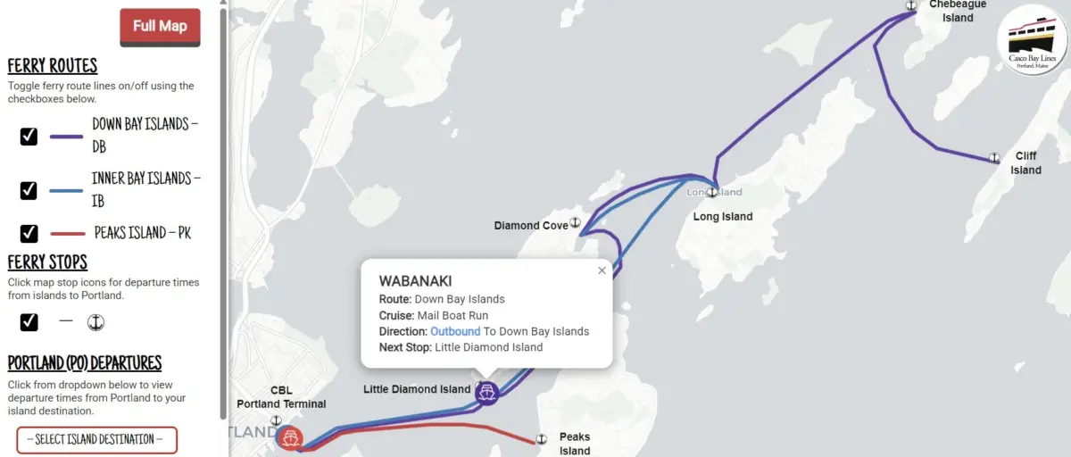
Casco Bay Lines (CBL), the historic lifeline connecting mainland Portland to the islands of Casco Bay, has officially unveiled its most significant technological upgrade in recent years: the CBL Live Map. Designed to bridge a storied maritime heritage with cutting-edge transit technology, this real-time tracking tool provides commuters, tourists, and island residents with instant, granular visibility into the daily movements of the Casco Bay ferry fleet.
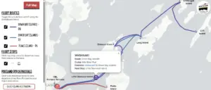
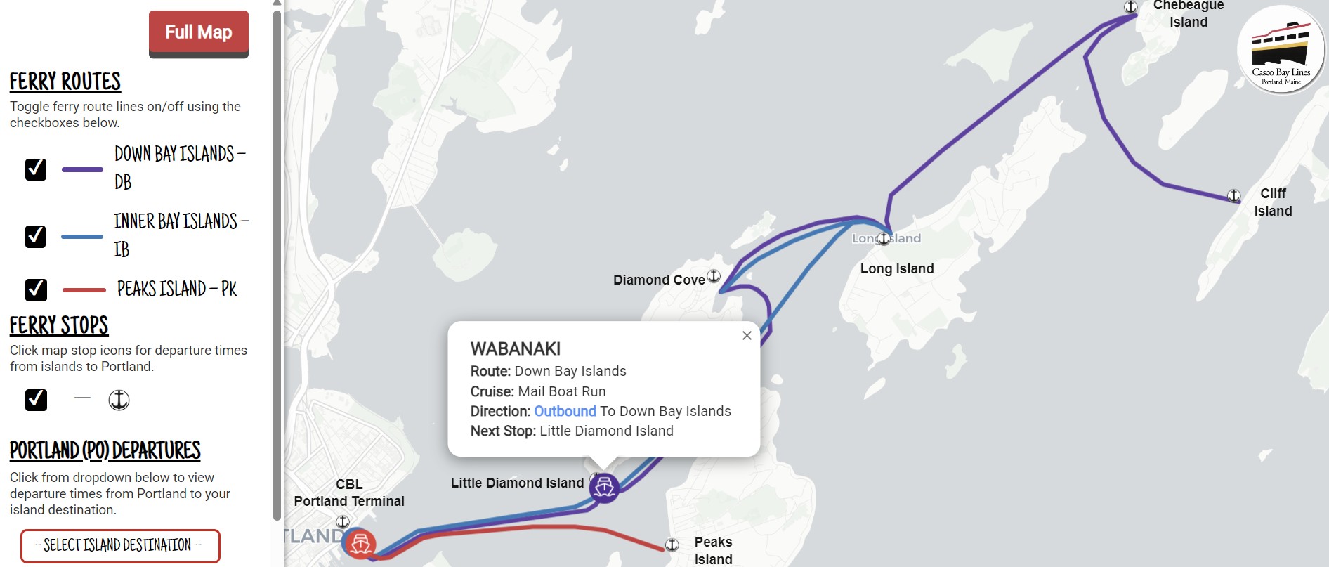
Following a soft launch earlier this fall, the tool has already generated considerable enthusiasm across the community. Commuters have lauded the application for its seamless interface, responsiveness, and reliability. Updated every 15 to 30 seconds, the interactive map allows users to monitor vessel locations across the bay, track real-time schedule adjustments, and plan journeys with unprecedented precision.
Beyond improving the passenger experience, the rollout represents a critical infrastructural milestone for Casco Bay Lines. By modernizing its foundational transit data infrastructure through a combination of federal grants, specialized cloud platforms, and local partnerships, CBL is significantly reducing informational bottlenecks at ticket windows, streamlining daily operations, and integrating its network into universally recognized mapping ecosystems like Google Maps, Apple Maps, and the Transit app.

Detailed Chronology: From Concept to Rollout
The realization of the CBL Live Map was not an overnight endeavor; rather, it was the culmination of a rigorous, multi-step technological evolution that accelerated in mid-2024.
Laying the Groundwork (July 2024)
The project began in earnest in July 2024, when Casco Bay Lines partnered with Pine Tree Project Management Pros, LLC, a Maine-based project management firm. Tasked with overseeing the complex integration of transit hardware and cloud architecture, Pine Tree Project Management Pros helped CBL navigate the procurement of sophisticated software solutions capable of translating maritime logistics into standardized, consumer-friendly digital formats.
The Tech Stack: Remix by Via and Swiftly, Inc.
To power the live tracking capabilities, CBL procured two robust cloud platforms:
- Remix by Via: This platform was implemented to format CBL’s historically intricate, seasonal sailing schedules into the General Transit Feed Specification (GTFS)—the global open-data standard for public transportation schedules and geographic data.
- Swiftly, Inc.: Operating in tandem with Remix, Swiftly was integrated to capture raw onboard GPS telemetry from the ferry fleet and convert it into GTFS-Realtime feeds.
By merging static schedule data with dynamic GPS tracking, the combined tech stack created a high-performance backend capable of instantly communicating vessel locations, projected arrivals, and real-time service disruptions.
The Quiet Fall Soft Launch
Before its official public debut, CBL quietly deployed the map earlier in the fall to test system performance under live operational conditions. The quiet rollout proved remarkably successful, stress-testing the architecture against daily commuter patterns and yielding immediate positive feedback. One regular commuter submitted an online review praising the initiative, noting: "Your new live map is absolutely awesome and works with ease. Good job."
Official Public Unveiling
Building on months of stable performance and enthusiastic reviews, CBL officially opened the tool to the broader public this month. The public launch includes dedicated instructional guides on the CBL website, helping users install the application directly onto their mobile home screens for rapid, app-like access.
Supporting Context & Metrics: Funding, Architecture, and Integration
The financial and technical framework behind the CBL Live Map reflects a collaborative effort across federal, regional, and private entities.
Funding and Financial Architecture
The project was made possible primarily through Federal Transit Administration (FTA) Section 5307 Urbanized Area Formula funds allocated for the Portland region. These federal dollars were specifically suballocated to Casco Bay Lines to support Intelligent Transportation Systems (ITS) upgrades. To secure the federal investment, CBL provided a mandatory 20% local funding match, demonstrating the organization’s commitment to self-improvement and infrastructure modernization.
Data Standardization and Ecosystem Integration
The implementation of GTFS and GTFS-Realtime standards did more than just power the CBL Live Map website. Because these protocols are recognized industry standards, the modernized backend now simultaneously feeds data into multiple third-party consumer applications, including:
- Google Maps
- Apple Maps
- The Transit App
- On-site terminal gate displays
This unified data pipeline ensures that whether a passenger checks their phone at home, consults a digital display at the Portland terminal, or uses a preferred third-party navigation app, they receive identical, up-to-the-minute service updates.
Operational Impact and Efficiency Metrics
Prior to the deployment of the GTFS-Realtime backend, Casco Bay Lines customer service staff handled a high volume of routine phone inquiries regarding vessel locations, departure times, and weather-related service advisories.
By shifting this information into an accessible, self-service digital format, CBL expects to see a measurable reduction in routine ticket-office calls. This frees up customer service representatives to focus on complex travel arrangements, ticketing operations, and passenger assistance. Furthermore, because GTFS is an open-source standard, the underlying architecture provides a scalable foundation for future operational tools, internal reports, and data-driven management decisions.
Official Statements and User Access
Casco Bay Lines has emphasized that while the organization takes immense pride in its maritime history, embracing modern digital tools is essential to meeting the evolving needs of the Portland and Casco Bay island communities.
How to Access the CBL Live Map
For passengers looking to utilize the new technology, CBL has streamlined access through two primary methods:
- Direct Web Access: Users can navigate directly to the live tracking portal at https://livemap.cascobaylines.com/.
- CBL Website & Mobile Integration: Visitors can head to the main CBL website homepage, click the "Live Map" button in the top navigation bar, and follow a simple, four-step tutorial to save the map directly to the home screen of an Apple iOS or Android mobile device.
The interface is intentionally designed to be lightweight, responsive, and intuitive, allowing users to instantly view active ferry positions, check island departure schedules back to Portland, and review critical service notices issued directly by transit staff.
Community Engagement
As part of its ongoing commitment to user-centric design, Casco Bay Lines is actively encouraging community members to submit their thoughts on the new tool. Riders who wish to share compliments, report bugs, or suggest additional features can access the official CBL Feedback and Report Form.
Future Outlook
The debut of the CBL Live Map marks a transformative turning point for Casco Bay Lines, yet leadership views this project as merely the foundational phase of a broader technological modernization strategy.
By establishing a clean, standardized GTFS and GTFS-Realtime data architecture, CBL has future-proofed its digital infrastructure. Moving forward, the open-standard nature of these platforms will allow the transit agency to layer on advanced operational analytics, predictive arrival algorithms, and enhanced communication tools. These future upgrades will further optimize fleet management, reduce fuel consumption through efficient routing, and enhance the overall reliability of Maine’s vital island transit network.
As Casco Bay Lines looks toward the horizon, the successful integration of real-time tracking proves that even historic maritime institutions can successfully harness modern cloud computing to better serve their communities—ensuring that generations of islanders, commuters, and visitors can navigate the waters of Casco Bay with absolute confidence.