





VALDEZ, ALASKA — In a major advancement for high-latitude marine infrastructure, TDI-Brooks has successfully completed a comprehensive geotechnical and geophysical subsea cable route survey in the Valdez Arm of Alaska. Executed on behalf of the global geospatial and architecture firm Woolpert, the project marks a significant milestone in the ongoing push to expand and secure robust telecommunications and power infrastructure across the sub-Arctic.
By leveraging its proprietary Gravity CPT (gCPT) Stinger system, TDI-Brooks bypassed the logistical and environmental bottlenecks historically associated with conventional offshore drilling. The operation delivered high-resolution, in-situ soil characterization data from the extreme marine environments of southern Alaska, providing engineers with the critical data needed to design, route, and protect vital underwater utility corridors.
Executive Overview: Bridging the Digital Divide in Rugged Environments
As global demand for high-speed connectivity and resilient electrical grids reaches the world’s most remote regions, the subsea cable sector has experienced an unprecedented surge in activity. Alaska, with its sprawling coastlines, steep fjord bathymetry, and seismically active waters, presents some of the most formidable engineering challenges on Earth.
The Valdez Arm—a deep-water fjord located in Prince William Sound—serves as a vital maritime gateway but features a highly complex seafloor characterized by glacial silt deposits, steep underwater slopes, and dynamic sediment movement.
+------------------------------------------------------------------------+
|                      VALDEZ ARM SURVEY QUICK FACTS                     |
+------------------------------------------------------------------------+
| Lead Contractor:      TDI-Brooks                                       |
| Client:               Woolpert                                         |
| Primary Technology:   Gravity CPT (gCPT) Stinger                       |
| Sensor Package:       Piezocone Penetrometer (PCPT)                    |
| Penetration Depth:    5 to 10+ meters below mudline (BML)              |
| Key Parameters:       Tip resistance, sleeve friction, pore pressure   |
+------------------------------------------------------------------------+
To establish a safe, long-term pathway for a new marine cable in this region, Woolpert commissioned TDI-Brooks to perform a rapid-deployment geotechnical and geophysical survey. The primary objective was to map the seafloor topography and evaluate the mechanical properties of the shallow sub-bottom soils.
Traditional geotechnical drilling methods in high-latitude environments are often cost-prohibitive, time-consuming, and environmentally sensitive. To overcome these constraints, TDI-Brooks deployed its advanced gCPT system. This specialized tool allows for the rapid collection of continuous, in-situ soil measurements without the need for heavy drilling rigs, drastically reducing the project’s carbon footprint and operational timeline.
Detailed Chronology of the Valdez Arm Operation
The execution of the Valdez Arm survey required meticulous planning, rapid mobilization, and precise coordination between marine geophysicists, geotechnical engineers, and vessel crew members.

Phase 1: Mobilization & Transit
  └── Selection of specialized vessel and calibration of gCPT sensors.
Phase 2: Geophysical Reconnaissance
  └── Mapping bathymetry, side-scan sonar, and sub-bottom profiling.
Phase 3: Geotechnical Deployment
  └── High-speed deployment of the gCPT Stinger system at targeted sites.
Phase 4: Real-Time Data Acquisition
  └── Continuous PCPT measurements down to 10+ meters below mudline.
Phase 5: De-mobilization & Reporting
  └── Quality control, data integration, and delivery of final engineering models.
Phase 1: Mobilization and Environmental Assessment
Operations began with the mobilization of a specialized survey vessel equipped with advanced dynamic positioning (DP) capabilities. Given the unpredictable weather patterns of the Gulf of Alaska and Prince William Sound, the technical team calibrated the gCPT system and auxiliary geophysical sensors in a controlled port environment before transiting to the Valdez Arm.
Phase 2: Geophysical Reconnaissance
Upon arriving at the survey site, the scientific team conducted a high-resolution geophysical sweep of the proposed cable corridor. Utilizing multibeam bathymetry, side-scan sonar, and sub-bottom profilers, the team mapped the seafloor’s surface topography and identified potential superficial hazards such as boulders, outcropping bedrock, and historical marine debris. This initial mapping phase was crucial for identifying the optimal locations for subsequent geotechnical testing.
Phase 3: Geotechnical Penetration and gCPT Deployment
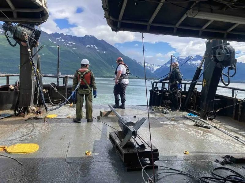
With the preliminary seafloor maps established, the vessel was positioned over target geotechnical stations. The gCPT Stinger system was deployed over the side of the vessel, utilizing a heavy-duty winch and A-frame assembly.
The gCPT system operates on a gravity-assisted free-fall and controlled-penetration mechanism. Upon release, the heavy stinger assembly accelerates through the water column, using its kinetic energy and mass to penetrate the seabed.
Phase 4: In-Situ Soil Data Collection
As the stinger penetrated the marine sediment, the integrated piezocone penetrometer (PCPT) immediately began transmitting real-time data back to the vessel’s laboratory. The system successfully pushed past the initial mudline, capturing continuous stratigraphic profiles down to 5 meters, with several penetration runs exceeding 10 meters below the mudline (BML).
Phase 5: Demobilization and Data Synthesis
Following the successful completion of all targeted penetration points, the gCPT tool was recovered, cleaned, and secured. The vessel returned to port for demobilization, while data analysts began compiling the raw geophysical and geotechnical datasets into a unified GIS database for Woolpert’s engineering team.

Supporting Context & Technical Metrics: The Science of the gCPT
To understand the significance of this project, one must examine the mechanics of the Gravity CPT Stinger and the physics of Piezocone Penetrometer Testing (PCPT).
Traditional offshore soil sampling relies on rotary drilling to extract physical core samples, which are then shipped to onshore laboratories for testing. This process can alter the natural state of the soil due to stress relief and mechanical disturbance during retrieval. In contrast, the gCPT system measures soil properties in-situ—directly within the seafloor in its undisturbed state.
       [ gCPT Stinger Rig ]
               │
               ▼
   ~~~~~~~~~~~~~~~~~~~~~~~~~  <-- Seafloor / Mudline
         ░░░░░░░░░░░
         ░░░ Soil  ░░  <-- Free-fall kinetic energy drives
         ░░ Layer ░░      the stinger deep into sediment
         ░░░░░░░░░░░
               │
               ▼  (Continuous sensor readings transmitted via umbilical)
       [ Piezocone Tip ]
         ├── Tip Resistance (qc)   --> Measures bearing capacity & density
         ├── Sleeve Friction (fs)  --> Measures soil cohesiveness & shear strength
         └── Pore Pressure (u2)    --> Identifies permeability & consolidation
Key Parameters Measured by the PCPT
The piezocone penetrometer tip features highly sensitive electronic transducers that measure three primary variables simultaneously:
- Tip Resistance ($q_c$): The force required to push the cone tip through the soil. High tip resistance indicates dense sands, gravels, or highly consolidated clays, whereas low resistance points to soft silts and loose clays.
- Sleeve Friction ($f_s$): The frictional force exerted on the cylindrical sleeve located immediately behind the cone tip. The ratio of sleeve friction to tip resistance (the friction ratio) is a key indicator of soil type and cohesive behavior.
- Pore Water Pressure ($u_2$): The pressure of the water trapped within the soil pores as the cone displaces the sediment. Measuring pore pressure behavior (including excess pore pressure generation and dissipation rates) allows geophysicists to determine soil permeability, consolidation characteristics, and drainage conditions.
Overcoming the Geotechnical Challenges of Valdez Arm
The Valdez Arm features a complex depositional environment. Glacial runoff continuously deposits fine-grained, low-cohesion silts into the fjord, creating thick sequences of soft, under-consolidated sediments. These conditions present several distinct hazards for subsea cables:
- Submarine Landslides and Slope Instability: Steep underwater slopes composed of loose, saturated silts are highly susceptible to downslope failure, particularly in a seismically active zone like southern Alaska. A submarine landslide can easily shear or displace an unprotected cable.
- Soil Liquefaction: During an earthquake, the sudden increase in pore water pressure within loose, saturated sands and silts can cause the soil to lose its shear strength and behave like a liquid. PCPT pore pressure and tip resistance data are essential for calculating a site’s liquefaction potential.
- Cable Trenchability: To protect cables from commercial fishing gear, anchors, and ice gouging, they must be buried (trenched) beneath the seafloor. The gCPT data provides direct insights into the "trenchability" of the soil, helping engineers select the right plow or jetting tools for the installation phase.
Official Statements and Industry Perspectives
The collaboration between TDI-Brooks and Woolpert highlights a growing industry trend toward utilizing agile, high-tech survey tools to compress project timelines while maintaining rigorous safety and environmental standards.
Project managers close to the operation emphasized the efficiency of the gCPT system in high-latitude environments. By utilizing in-situ testing, the field crew was able to capture high-density data points in a fraction of the time required for traditional boring operations. This rapid turnaround is critical in Alaska, where operational windows are tightly constrained by weather, seasonal fish migrations, and challenging marine conditions.
Geotechnical specialists noted that the continuous profiling capability of the piezocone penetrometer provides a level of stratigraphic detail that physical core sampling often misses. In glaciomarine environments, soil conditions can change rapidly over just a few meters. The real-time data stream from the gCPT allowed the offshore team to adjust their survey grid dynamically, ensuring that any localized anomalies, such as buried gravel lenses or soft clay pockets, were fully mapped and characterized.
Future Outlook: The Arctic Digital Frontier and Infrastructure Expansion
The successful completion of the Valdez Arm survey comes at a time of unprecedented investment in high-latitude marine infrastructure. The Arctic and sub-Arctic regions are undergoing a digital transformation, driven by the need to connect remote coastal communities, support maritime commerce, and bolster national security communications.
+-----------------------------------------------------------------------+
|                    FUTURE DRIVERS OF SUBSEA SURVEYS                   |
+-----------------------------------------------------------------------+
| 1. High-Latitude Fiber Networks: Connecting remote Arctic communities.|
| 2. Climate Change Adaptation: Mapping unstable slopes and thawing     |
|    subsea permafrost.                                                 |
| 3. Green Energy Corridors: Off-shore wind and tidal power integration.|
| 4. Cost-Efficiency Demands: Shift from heavy drilling to agile,       |
|    low-impact in-situ tools like the gCPT.                            |
+-----------------------------------------------------------------------+
The Rise of Arctic Fiber-Optic Networks
Several high-profile subsea fiber-optic initiatives are currently underway or in planning stages across the global north, including trans-Arctic routes connecting Asia to Europe via the Northwest Passage and regional networks aimed at closing the digital divide in rural Alaska. These projects require thousands of kilometers of subsea cabling, all of which must undergo rigorous routing surveys to ensure long-term survivability.
Climate Change and Geotechnical Instability
Climate change is rapidly altering the sub-Arctic marine environment. Rising water temperatures, melting glaciers, and degrading subsea permafrost are changing the stability of coastal and deep-water slopes. Geotechnical baseline surveys, such as those performed by TDI-Brooks, are becoming increasingly vital to monitor these shifting baselines and design resilient infrastructure that can withstand changing seafloor dynamics over multi-decadal lifespans.
Technical Evolution of Marine Geotechnical Tools
The success of the gCPT Stinger in the Valdez Arm demonstrates the viability of gravity-deployed in-situ tools for demanding engineering projects. Looking ahead, the offshore industry is expected to see further integration of automated and robotic systems for seafloor characterization.
By refining the sensor capabilities of gravity-based penetrometers and pairing them with autonomous surface vessels (ASVs) and autonomous underwater vehicles (AUVs), marine survey firms will be able to map vast stretches of the ocean floor with unprecedented speed, safety, and resolution.
As Woolpert moves forward with the engineering and design phases of the Valdez Arm cable route, the high-resolution data provided by TDI-Brooks will serve as the foundation for the project’s success. By combining advanced geotechnical science with robust maritime execution, this project sets a new benchmark for how critical infrastructure can be safely and efficiently planned in the world’s most challenging marine frontiers.