











By Blake Aued
Published October 2, 2026
Executive Overview
The foundational anatomy of the world’s most vibrant, enduring cities shares a single, undeniable common denominator: a fine-grained street grid composed of small, permeable blocks. From the historic districts of European capitals to the iconic nineteenth-century expansion plans of Manhattan, dense webs of interconnected pathways have historically served as the lifeblood of urban commerce, social cohesion, and pedestrian freedom.
Yet, over the past several decades, a quiet transformation has reshaped the American landscape. Municipalities across the United States have steadily abdicated one of their most fundamental, consequential civic responsibilities—the design and layout of public streets. In the interest of short-term fiscal relief, streamlined approval processes, and private-sector efficiency, local governments have increasingly ceded urban planning and street network design directly to private real estate developers.
The consequences of this paradigm shift have proven profound. When developers, driven by profit margins and suburban-style macro-subdivision models, take charge of mapping the public realm, urban connectivity suffers. The resulting landscapes are routinely characterized by sprawling superblocks, auto-centric cul-de-sacs, fragmented pedestrian pathways, and a severe deficit of spatial redundancy. This investigative report examines how the abdication of public oversight occurred, the structural mechanics of developer-led street design, the long-term socio-economic and environmental tolls on American municipalities, and the urgent imperative for cities to reclaim control of their blueprints.
Detailed Chronology: The Shift from Public Vision to Private Blueprint
The Historical Precedent: The Era of Municipal Mastery
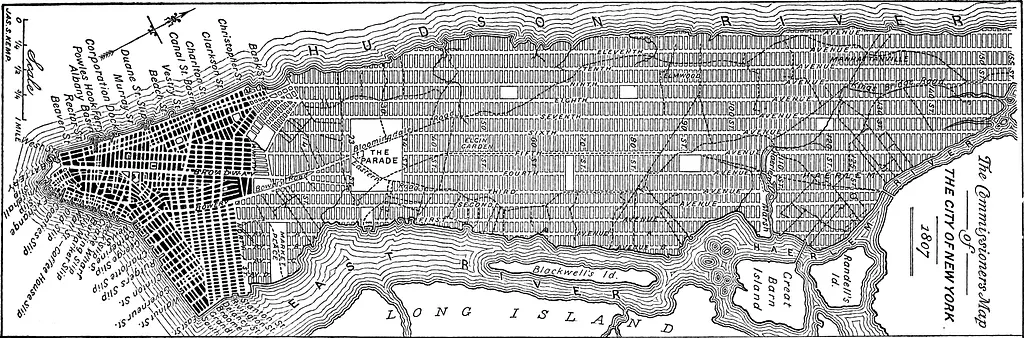
For centuries, the laying out of streets was viewed as an essential function of sovereign or municipal authority. When cities grew—whether through deliberate planning, as seen in the Commissioners’ Plan of 1811 that cast New York City’s famous grid, or through organic expansion tightly regulated by municipal ordinances—public officials dictated the terms of circulation.
The rationale was simple: streets are not merely private access drives for adjacent parcels; they are permanent public infrastructure, perpetual assets meant to outlive any single building, business, or generation. Urban planners and civil engineers working on behalf of the public interest prioritized network resilience, ensuring that multiple alternative routes existed to prevent traffic bottlenecks, encourage diverse economic activity, and provide equitable access for pedestrians, transit users, and commerce alike.

The Rise of Suburbanization and the Cul-de-Sac Model (Mid-to-Late 20th Century)
The erosion of public street design began in earnest during the post-World War II suburban boom. As federal policies, highway funding, and housing incentives favored low-density expansion, cities and suburban townships alike adopted zoning codes that heavily favored separation of uses and sprawling, disconnected subdivisions.
During this era, private developers largely assumed responsibility for internal subdivision layouts, subject to increasingly formulaic subdivision regulations (subdivision controls). Rather than integrating new developments into a continuous, fine-grained grid, municipalities permitted developers to construct isolated pods connected to the broader urban fabric by only a few high-capacity arterial roads. This model prioritized immediate vehicular throughput over neighborhood permeability, sowing the seeds for the car-dependent developments that define modern American sprawl.
The Neoliberal Turn: Public-Private Partnerships and "Streamlining" (1990s–2010s)
As municipal budgets faced mounting pressures in the late twentieth and early twenty-first centuries, local governments increasingly turned to the private sector to shoulder the costs of infrastructure installation. Under the banner of "streamlining" and economic development, cities began to rely on private developers not just to build streets within their specific tracts, but to design them from scratch under broad, permissive performance standards.
In many high-growth regions, cash-strapped planning departments lacked the staff, resources, or political backing to mandate rigorous, interconnected street grids. Instead, developers offered master-planned communities, mixed-use lifestyle centers, and master-planned corporate campuses that functioned as private enclaves. Municipalities, eager for property tax revenue and relieved of the upfront capital expenditure of master-planning large tracts of land, readily signed off on developer-drafted street networks.
The Modern Reality: The Consolidated Superblock (Present Day)
Today, this trend has matured into a systemic urban design crisis. Across fast-growing metropolitan areas, new developments routinely feature massive superblocks—parcels spanning dozens or even hundreds of acres enclosed by high-speed arterials, with internal circulation restricted to circuitous private drives or wide, pedestrian-hostile thoroughfares.
By surrendering the drawing board to corporate entities whose primary incentive is maximizing leasable square footage and minimizing infrastructure maintenance liabilities, cities have allowed the historic grid to be replaced by a disjointed patchwork of private fiefdoms.

Supporting Context & Metrics: The Anatomy of the Grid vs. The Superblock
To understand why the privatization of street design is detrimental, one must examine the measurable performance metrics that distinguish a fine-grained grid from a developer-designed superblock network.
Block Size and Intersection Density
- The Fine-Grained Grid: Traditional urban grids typically feature block lengths ranging from 200 to 400 feet, yielding high intersection densities (often exceeding 100 intersections per square mile). This high density creates hundreds of alternative paths for any given journey, naturally dispersing traffic and keeping vehicular speeds low and safe.
- The Developer Superblock: Modern master-planned developments often feature block lengths exceeding 800 to 1,500 feet, with intersection densities dropping precipitously. Pedestrians are forced to walk massive detours to cross a street, while all local traffic is funneled onto a handful of congested, high-speed collector roads.
Economic Vitality and Land Productivity
Urban economics literature consistently demonstrates that small blocks generate higher land productivity.
- Smaller blocks mean more corner properties, which command higher commercial rents and foster foot traffic.
- A dense street network divides land into manageable parcels, allowing for incremental, organic development by a diverse array of small businesses and property owners.
- Developer-led master plans, by contrast, tend toward large-format footprints designed for single corporate tenants, big-box retailers, or homogenous residential pods, suppressing long-term economic resilience and adaptability.
Safety and Public Health Metrics
The physical layout of a street directly impacts public safety:
- Traffic Violence: According to transportation safety data, pedestrian and cyclist fatalities are disproportionately concentrated on wide, high-speed arterial roads that typify developer-designed suburban and semi-urban fringes. Traditional grids, with their inherent friction and slower speeds, record significantly lower rates of severe traffic injuries.
- Active Transportation: Compact grids encourage walking and cycling by making active transit the most direct, efficient route. Conversely, disconnected developer layouts make walking cumbersome, unpleasant, and often hazardous, locking communities into mandatory car dependency.
Official Statements and Expert Perspectives
Urban planners, transportation advocates, and municipal leaders have become increasingly vocal regarding the risks of ceding public infrastructure to private hands.
"When a city hands over the design of its streets to a private developer, it is permanently mortgaging its future public health, economic dynamism, and social equity for a short-term development concession," notes Dr. Elena Vance, Professor of Urban Planning at the National Institute of Infrastructure Studies. "Streets are the skeleton of the city. You wouldn’t let a private contractor design your skeleton; you shouldn’t let them design the permanent public realm either."
Industry representatives, however, often defend the practice by pointing to regulatory hurdles and financial constraints. Speaking on condition of anonymity, a senior project manager for a major national real estate development firm argued:

- "Municipalities often lack the capital and the vision to plan infrastructure for large, raw tracts of land in a timely manner. Our job is to deliver functional, market-viable communities that comply with local zoning ordinances. If the zoning code permits a lower-density layout with fewer connection points, we design to meet that market demand efficiently."
Urban design reformers counter that the problem lies precisely in the permissiveness of antiquated zoning and subdivision codes. When cities fail to establish strong, binding master street plans, they invite developers to optimize for private return rather than public longevity.
Future Outlook: Reclaiming the Public Blueprint
Reversing decades of privatized street design will require a deliberate, structural overhaul of municipal planning philosophy and regulatory frameworks. As American cities grapple with housing affordability, climate change, and the urgent need to transition away from car dependency, reforming how streets are conceived and constructed is paramount.
1. Codifying the Mandatory Grid
Forward-thinking municipalities are beginning to rewrite their subdivision regulations to legally prohibit the creation of superblocks. By mandating maximum block lengths and requiring strict interconnectivity standards for any new development parcel, cities can force developers to plug into the broader urban fabric rather than building isolated islands.
2. Revitalizing Municipal Engineering and Planning Departments
For decades, cities downsized their internal planning and civil engineering capabilities, leaning on outside consultants and developer-funded studies. To reclaim the public realm, local governments must reinvest in robust, visionary municipal planning departments capable of drafting comprehensive master street plans before developers break ground.
3. Prioritizing Public Wealth Over Private Convenience
Streets are among the most valuable public assets a community possesses. Treating them as mere residual spaces left over after a real estate parcel is carved up is a recipe for long-term fiscal and social decline. By reclaiming the drawing board, cities can ensure that growth enhances—rather than degrades—the public realm for generations to come.
Streetsblog continues to cover the movement to end car dependency and improve walking, biking, and transit across America. Have a tip or a local story to share? Contact our editorial team at [email protected].