










Executive Overview
Tucked deep within the ancient, weathered folds of the Missouri Ozarks lies a geological and ecological anomaly: the Glade Top Trail. Spanning 23 miles of winding, unpaved gravel through the heart of the Mark Twain National Forest, this route holds the distinct honor of being Missouri’s only National Forest Scenic Byway. For travelers seeking a respite from the neon-soaked, kitschy entertainment strips of nearby Branson—situated a mere hour away—the trail offers an immediate, immersive transition into raw, undisturbed American wilderness.
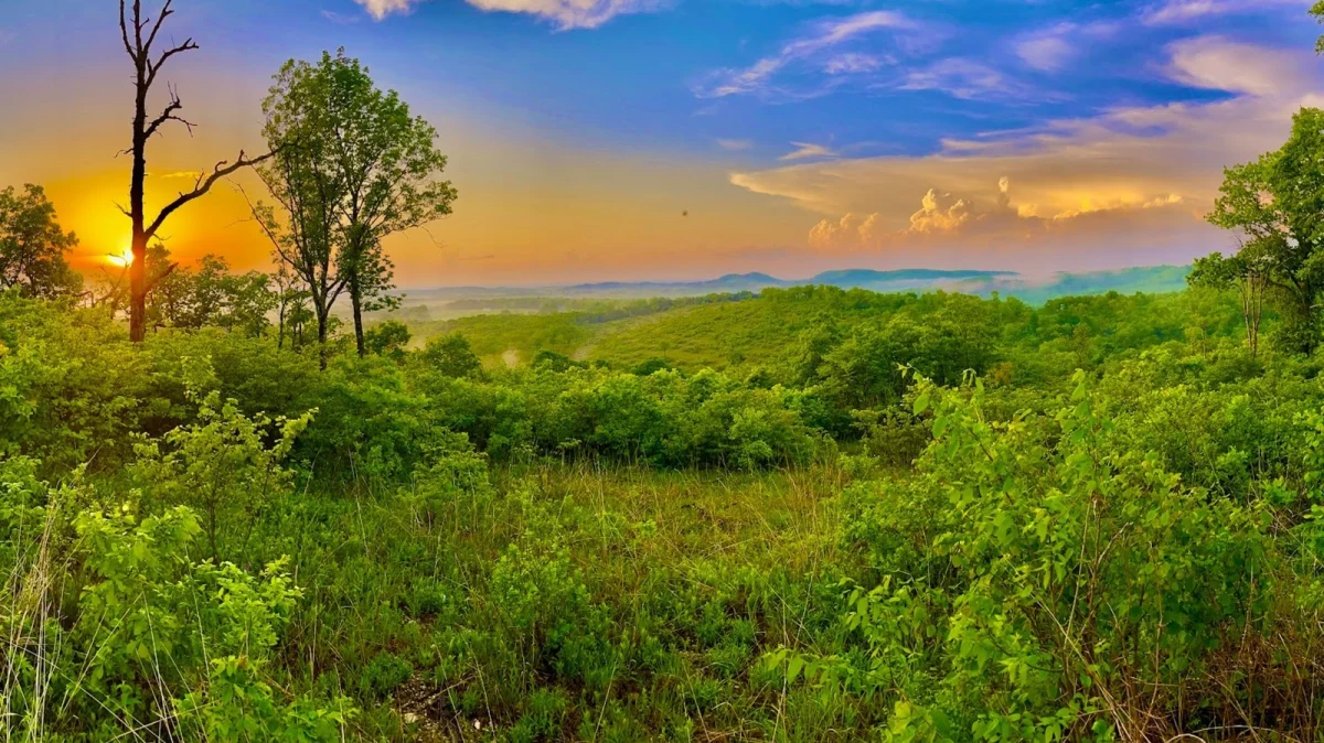
Yet, the Glade Top Trail is far more than a convenient day trip or a casual Sunday drive. It is a portal to a delicate, increasingly rare ecosystem. The byway traverses high-elevation ridge tops that afford sweeping, panoramic views of the Springfield Plateau, the distant Boston Mountains of Arkansas, and an undulating sea of hardwood forests. More importantly, it serves as a frontline for the preservation of Missouri’s dolomite and limestone glades—sun-drenched, bedrock-driven clearings that support flora and fauna found nowhere else on earth.
However, experiencing this pristine environment requires preparation and respect. Unlike the heavily engineered, smooth-paved highways that crisscross much of the American landscape, the Glade Top Trail demands mindfulness. Characterized by narrow stretches, shifting gravel surfaces, cattle guards, and occasional remote isolation, it bridges the gap between accessible tourism and rugged back-country exploration.
This comprehensive report examines every facet of the Glade Top Trail. From its ecological significance and logistical driving realities to family-oriented amenities, historical access points, and long-term conservation outlooks, this feature serves as the definitive guide for navigating Missouri’s most captivating scenic byway.
Detailed Chronology & Historical Context: Shaping the Ozark Ridges
To fully appreciate the Glade Top Trail, one must understand the deep geological and historical forces that shaped the southern Missouri landscape. The story of the Ozarks is written in stone—specifically, the thick layers of dolomite and limestone deposited by shallow prehistoric seas hundreds of millions of years ago. Over vast expanses of geological time, tectonic uplift and relentless erosion carved these sedimentary layers into the dramatic plateaus, steep valleys, and dramatic ridges seen today.
The Rise of the Glades
The defining feature of the byway—the glades themselves—are ancient natural phenomena. Unlike the surrounding dense hardwood forests, glades are open, sun-baked environments where bedrock breaches the thin soil surface. Because these clearings are exposed to the fierce glare of the midday sun and the biting frost of winter, they create microclimates reminiscent of southwestern deserts or arid plains, despite sitting firmly within the humid subtropical climate of the Midwest.
Historically, these glades were maintained by periodic, low-intensity natural wildfires sparked by lightning, as well as controlled burns historically managed by indigenous populations. These fires kept encroaching eastern red cedars and dense brush at bay, allowing drought-tolerant, sun-loving plants to thrive.

Development of the Byway
For generations, the high ridge roads that now comprise the Glade Top Trail were little more than logging tracks, remote timber-hauling routes, and basic rural thoroughfares used by early Ozark settlers, homesteaders, and forest rangers. The area’s rugged terrain made permanent agricultural development difficult, leaving much of the land wild.
Recognizing the extraordinary scenic, recreational, and ecological value of these high ridges, the United States Forest Service eventually formalized and designated the route as the Glade Top Trail National Forest Scenic Byway. Unlike modern civil engineering projects designed to maximize speed and efficiency, the byway was intentionally routed to follow the natural contours of the land. It hugs the spines of Pilot Knob, Long Mountain, and other prominent ridges, ensuring that travelers experience the terrain from a bird’s-eye perspective.
Today, the trail operates as a carefully managed corridor within the sprawling 1.5-million-acre Mark Twain National Forest. It balances the demands of modern vehicular recreation with the imperative of protecting fragile ecosystems that took millennia to form.
Supporting Context & Metrics: The Ecosystem and Logistics of the Byway
Driving the Glade Top Trail is an exercise in sensory immersion, but it is also an encounter with precise geographical, ecological, and logistical realities. Understanding these metrics ensures a safe, rewarding, and ecologically responsible visit.
Ecological Wealth: Flora and Fauna
The glades crossed by the trail are biodiversity hotspots. Because the vegetation must endure extreme thermal shifts and moisture stress, highly specialized endemic species have evolved here.
- Botanical Highlights: Visitors exploring the trail during the spring and summer months will encounter a succession of vibrant wildflowers, including Missouri evening primrose, purple coneflower, pale purple coneflower, and various native grasses like little bluestem. Rare species, such as the Ozark chinquapin and specific glade-dwelling cacti, find vital refuge here.
- Fauna: The open glade-forest ecotones (transition zones) support an eclectic mix of wildlife. While driving or hiking, visitors frequently spot wild turkeys strutting along the woodlines, swift-moving collared lizards basking on hot limestone rocks (locally and affectionately known as "mountain boomers"), and roadrunners darting through the brush.
Navigational Metrics and Road Conditions
While scenic drives are often categorized by their ease of completion, the Glade Top Trail sits in a nuanced category.
- Length: Exactly 23 miles of continuous unpaved roadway.
- Surface Composition: Crushed limestone and native gravel. The road is routinely graded by the U.S. Forest Service, making it passable for standard two-wheel-drive passenger vehicles and sedans under normal, dry weather conditions.
- Infrastructure Challenges: The route features narrow sections with limited shoulders, steep drop-offs without extensive guardrails, and multiple cattle guards designed to manage local livestock grazing allotments.
- Clearance and Rental Restrictions: While high-clearance vehicles or four-wheel-drive (4WD) systems are not strictly mandatory during dry summer months, they become highly beneficial following heavy rain events when mud and washboard ruts develop. Furthermore, travelers utilizing rental vehicles must carefully scrutinize their rental agreements; many major commercial rental fleets explicitly prohibit operation on unpaved or gravel roads, rendering insurance void in the event of tire punctures or body damage.
Recreational Infrastructure
The byway is not merely a drive-through attraction; it serves as a staging ground for deeper exploration into the Mark Twain National Forest.
- Turn-outs: There are seven designated scenic overlooks strategically positioned along the ridge tops. These pull-offs feature unobstructed vistas stretching across the rolling hills of the Springfield Plateau toward the distant horizon.
- Campgrounds and Trails: Dispersed camping is permitted in designated areas along the byway, offering a true wilderness experience without the amenities of commercial campgrounds. A prominent hub for overnight stays and trail access is the Willie Lee Campground. From here, visitors can access the 16-mile Bateman Trail, a rugged footpath that plunges off the ridges into creek bottoms, weaving through dense woods and open glades.
Official Statements and Forest Service Guidelines
Managing a multi-use national forest scenic byway requires a delicate balance between public access and environmental stewardship. The United States Department of Agriculture (USDA) Forest Service, which oversees the Mark Twain National Forest, issues explicit guidelines and educational frameworks to ensure the long-term health of the Glade Top Trail corridor.
Conservation and Land Management Perspectives
According to Forest Service ecologists and district rangers, the primary management challenge along the Glade Top Trail involves mitigating the threats of invasive species and preventing unauthorized off-road vehicle (OHV) use that can permanently scar fragile glade soils.
"The dolomite and limestone glades found along the Glade Top Trail represent irreplaceable natural heritage sites within the Ozark ecosystem," notes regional Forest Service literature. "The thin soils that support these rare plant communities are exceptionally vulnerable to compaction and erosion. We urge all visitors to remain on designated roadways, trails, and established turn-outs to protect these delicate habitats for future generations."
The Forest Service actively utilizes prescribed fire programs in and around the byway viewshed. By periodically reintroducing controlled burns, management teams mimic historical natural fire regimes, successfully pushing back invasive eastern red cedar trees and stimulating the resurgence of native warm-season grasses and wildflowers.
Technological Integration for Youth Engagement
Recognizing the need to engage younger generations in outdoor conservation, the Forest Service has partnered with interactive digital platforms. Along the byway, particularly near the Caney Picnic Area—a favored stop for panoramic views and family lunches—children and families are encouraged to utilize the Agents of Discovery mobile application.
Forest Service officials emphasize the educational value of this initiative:
"We want families to experience the Mark Twain National Forest in ways that resonate with modern kids while fostering a genuine, science-based appreciation for nature," a Forest Service interpretive spokesperson explains. "The Agents of Discovery missions transform static picnic stops into dynamic outdoor classrooms. Children complete location-based challenges that teach them about local geology, botany, and wildlife ecology directly within the environment they are visiting."
Officials routinely remind the public to download these interactive missions prior to departure, as cellular network connectivity along the remote, high-ridge byway is notoriously unreliable or entirely absent.
Future Outlook: Preservation, Tourism, and Sustainable Access
As tourism trends shift toward outdoor recreation, localized road trips, and nature-based wellness, the Glade Top Trail faces a pivotal future. The increasing influx of visitors seeking authentic escapes from urban and commercial centers places both opportunities and pressures on this delicate Ozark ecosystem.
Balancing Tourism Growth with Ecological Integrity
The proximity of the byway to booming entertainment hubs like Branson ensures a steady stream of curious travelers. However, municipal and federal planners are keenly aware that unchecked tourism can degrade the very qualities that make the Glade Top Trail attractive.
Future outlooks for the region heavily emphasize sustainable tourism models. This includes:
- Infrastructure Hardening: Upgrading drainage culverts and resurfacing critical gravel sections to prevent accelerated erosion during intense storm events driven by changing regional climate patterns.
- Visitor Education: Expanding digital signage, trailhead kiosks, and mobile app integration to instill "Leave No Trace" principles among first-time national forest visitors who may be unfamiliar with back-country protocols.
- Habitat Restoration Partnerships: Continuing collaborative efforts between federal agencies, botanical societies, and local volunteer groups to aggressively remove invasive plant species and expand native glade restoration projects along the ridge corridors.
The Evolving Visitor Experience
Looking ahead, the Glade Top Trail is poised to remain a treasured secret that occasionally captures broader national attention. Whether travelers come for a fleeting two-hour scenic drive complete with autumn foliage viewing, spring wildflower spotting, or as a rugged staging point for multi-day backpacking and equestrian excursions into the Mark Twain National Forest, the trail endures as a testament to the untamed spirit of the Ozarks.
Ultimately, the enduring appeal of the Glade Top Trail lies in its resistance to over-commercialization. By refusing to pave its winding paths or install urban amenities, the byway preserves an authentic connection to the past. It challenges modern travelers to slow down, engage with the natural world on its own terms, and witness a rugged landscape where stone, sky, and ancient forests still reign supreme.