








Executive Overview
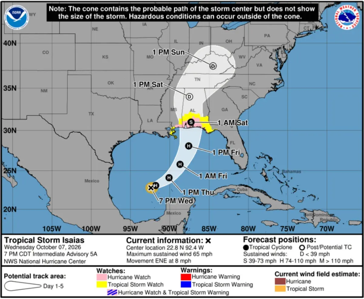
As the Atlantic hurricane season enters its peak months, cruise operators across the Caribbean and Gulf of Mexico are once again forced to play a high-stakes game of maritime chess. Tropical Storm Isaias is currently churning over the warm waters of the Gulf of Mexico, steadily gaining power and organization. According to the latest advisory from the National Hurricane Center (NHC), the storm is packing maximum sustained winds of 65 miles per hour and is widely expected to strengthen into a Category 1 hurricane before making landfall.
In response to the intensifying system, Carnival Cruise Line has activated its comprehensive severe weather protocols, issuing proactive communications to thousands of passengers. The cruise giant is closely monitoring the developing weather pattern across six distinct vessels, impacting a total of 12 upcoming sailings and current voyages. These alerts have been distributed via formal letters delivered directly to staterooms for guests currently at sea, alongside automated text message notifications to travelers preparing to embark in the coming days.
While major Gulf homeports such as Galveston, Texas, and New Orleans, Louisiana, are not currently in the direct crosshairs of the storm’s projected landfall, the atmospheric hazards extend far beyond the eye of the system. Isaias’s current projected trajectory cuts directly across critical maritime corridors. These sea lanes are heavily relied upon by cruise ships transiting between mainland United States ports and the tropical destinations of the Western and Eastern Caribbean. Consequently, even minor shifts in the storm’s forward speed or heading could trigger cascading itinerary modifications, port omissions, and delayed returns.
This comprehensive report examines the current status of Tropical Storm Isaias, details Carnival Cruise Line’s operational response, evaluates the potential impacts on specific vessels, and provides essential context for travelers navigating cruise vacations during an active Atlantic hurricane season.
Detailed Chronology: Tracking Isaias and the Industry Response
The meteorological evolution of Tropical Storm Isaias has been closely tracked by both marine meteorologists and cruise line dispatchers. Understanding the timeline of the storm’s development highlights how rapidly cruise operators must adapt their logistical planning to ensure passenger and crew safety.
Meteorological Timeline and NHC Advisories
- October 7 (Afternoon): Atmospheric conditions in the western Gulf of Mexico show favorable parameters for tropical cyclogenesis. Sea surface temperatures remain well above the 26.5°C threshold required to sustain and intensify tropical systems, providing abundant thermal energy to the developing disturbance.
- October 7 (7:00 PM CDT): The National Hurricane Center issues a critical advisory placing the center of Tropical Storm Isaias approximately 200 miles west-northwest of Progreso, Mexico. At this juncture, the storm exhibits maximum sustained winds of 65 MPH and is maintaining a slow, deliberate forward motion toward the east-northeast at approximately 8 MPH. Forecasters note steady organization within the convection bands, signaling an imminent transition into a Category 1 hurricane.
- October 7 (Evening): Realizing the potential disruption to Gulf maritime traffic, Carnival Cruise Line’s Fleet Operations Center in Miami initiates contact protocols. Communications are drafted and disseminated to impacted ships at sea and upcoming passengers on manifest rosters.
- October 8 (Morning): Carnival Valor approaches the conclusion of its five-night western Caribbean voyage. Operations managers confirm that the ship will return to its homeport of New Orleans on schedule, though subsequent voyages face heightened scrutiny.
The Operational Decision-Making Process
For a major cruise line like Carnival, monitoring a tropical storm is not merely a matter of watching weather maps; it requires a complex calculus involving fuel consumption, guest satisfaction, port authority coordination, and safety margins.
When a system like Isaias forms in the Gulf, cruise dispatchers evaluate several variables simultaneously:
- Homeport Accessibility: Ensuring that departure and arrival ports remain clear of sustained gale-force winds and storm surges that could close shipping channels or restrict pilotage services.
- Sea State Management: Calculating wave heights and swell directions to avoid uncomfortable or unsafe sailing conditions for passengers and crew. Large cruise ships possess significant windage—acting essentially as floating high-rise buildings—which makes high crosswinds particularly challenging during docking maneuvers.
- Alternative Itineraries: Pre-planning alternative routes that allow ships to outrun or detour around severe weather systems, substituting missed ports with sea days or alternative destinations in unaffected regions (such as shifting from the Western Caribbean to the Bahamas or Eastern Caribbean, operational constraints permitting).
Supporting Context & Metrics
Operating cruise vessels during hurricane season requires an understanding of both maritime geography and meteorological data. The current geographic footprint of Tropical Storm Isaias presents unique challenges due to the geography of the Gulf of Mexico.
Geographic Analysis of the Threat
The Gulf of Mexico is a semi-enclosed basin where tropical systems can intensify rapidly due to high heat content in the upper ocean layers. However, its restricted dimensions also mean that storms moving across the basin can quickly affect major shipping lanes.
- Current Location: 200 miles west-northwest of Progreso, Mexico.
- Movement: East-northeast at 8 MPH. This relatively slow forward speed allows forecasters a clearer picture of the storm’s trajectory, but it also means the system has more time to drop heavy rainfall and generate prolonged heavy swells across a wide swath of the Gulf.
- Projected Landfall: Current consensus forecast tracks Isaias to make landfall just east of Mobile, Alabama. Notably, there are no major active cruise homeports directly positioned at the immediate landfall zone for this specific trajectory.
- The Crucial Bottleneck: While the eye of the storm may miss major cruise hubs, its expansive wind and rain fields intersect directly with the primary maritime highways connecting Galveston and New Orleans to the Yucatan Peninsula, Cozumel, Belize, and Honduras. Cruise ships departing from Texas and Louisiana must navigate these corridors to access Western Caribbean itineraries.
Fleet Impact Overview
Carnival Cruise Line has cast a wide net in its monitoring efforts, placing six distinct vessels across 12 individual sailings under formal weather watches. This proactive stance ensures that travelers are neither caught unaware nor left uninformed as meteorological conditions evolve.
| Vessel Name | Homeport / Region | Status / Current Operation | Projected Impact Level |
|---|---|---|---|
| Carnival Valor | New Orleans, LA | Completing 5-night Western Caribbean cruise; returning Oct 8. | Low for current arrival; High watch for Oct 8 departure. |
| Carnival Dream | Gulf of Mexico Itinerary | Currently at sea on an active cruise; issued onboard notifications on Oct 7. | Moderate (Monitoring route adjustments). |
| Carnival Breeze | Texas / Gulf Region | Preparing for October 10 departure; issued passenger advisories via text. | Moderate (Awaiting further meteorological updates). |
| Unnamed Vessel 4 | Gulf / Caribbean Transit | Under active monitoring by Miami Fleet Operations. | Low to Moderate |
| Unnamed Vessel 5 | Gulf / Caribbean Transit | Under active monitoring by Miami Fleet Operations. | Low to Moderate |
| Unnamed Vessel 6 | Gulf / Caribbean Transit | Under active monitoring by Miami Fleet Operations. | Low to Moderate |
Official Statements and Onboard Communications
Transparency is a cornerstone of modern cruise line crisis management. To prevent misinformation and reduce passenger anxiety, Carnival Cruise Line has authorized both shipboard leadership and shoreside guest relations teams to communicate directly and transparently with travelers.

Captain Zvonko Anic’s Address to Carnival Dream Guests
Onboard the Carnival Dream, Captain Zvonko Anic addressed passengers directly through a formal written notification distributed to all staterooms on October 7. The message was designed to reassure guests while maintaining realistic expectations regarding the unpredictable nature of tropical weather:
"In partnership with our Fleet Operations Center in Miami, we are actively monitoring Tropical Storm Isaias. Currently, there is no adjustment to our plans, but since forecasts can change, we will continue to monitor the weather and provide timely updates as we sail."
This statement underscores the collaborative relationship between shipboard masters, who possess immediate tactical control of the vessel, and shoreside meteorologists and dispatchers in Miami, who analyze macro-level weather patterns across the entire region.
Guest Communications for Upcoming Departures
For passengers preparing to embark on upcoming voyages, the communication strategy relies heavily on digital alerts. Guests booked on the October 10 sailing of the Carnival Breeze received direct text message notifications from the cruise line’s customer operations center.
The text message succinctly updated travelers on the current operational posture:
"At present, there are no changes to our plans."
While these messages carry a reassuring tone, seasoned cruisers understand that phrases like "at present" serve as a deliberate caveat. Weather patterns in the Gulf can shift rapidly within a 24-to-48-hour window, requiring travelers to remain flexible and closely monitor official cruise line communication channels, including email and the Carnival Hub app.
Future Outlook and Guidance for Travelers
As Tropical Storm Isaias continues its march across the Gulf of Mexico toward an expected Category 1 hurricane status, the coming days will be critical for Gulf-based cruise operations.
What to Expect Next
- Itinerary Modifications: The Carnival Valor departure on October 8 will serve as the bellwether for the fleet. If the storm’s track holds or shifts slightly south, Valor may be the first vessel to execute a confirmed itinerary change, potentially bypassing Western Caribbean ports in favor of eastern routes or extended sea days away from the storm track.
- Port Access Assessments: Local port authorities in New Orleans, Galveston, and Mobile will coordinate closely with the United States Coast Guard (USCG) to monitor channel conditions, wave action, and pilot availability as the storm approaches landfall.
- Communication Cadence: Carnival has committed to providing timely updates. Passengers currently onboard or scheduled to sail within the next week should check their mobile devices and the Carnival Hub app frequently for real-time notifications.
Cruising During Hurricane Season: Essential Advice
Cruising during the Atlantic hurricane season (which officially runs from June 1 through November 30) offers distinct advantages—such as competitive pricing and lower crowd densities—but it inherently requires a flexible mindset.
- Ships Outrun Storms: Modern cruise ships are marvels of marine engineering, capable of speeds exceeding 20 knots. This mobility allows captains to routinely outrun or detour around severe weather systems. Statistically, passengers on a cruise ship are far safer at sea than travelers stranded in a stationary coastal resort threatened by a hurricane.
- Itinerary Changes Are Not Cancellations: Passengers must remember the "ticket contract" agreement: cruise lines reserve the right to alter itineraries, substitute ports, or delay embarkation/debarkation times in the interest of safety. These changes do not automatically qualify guests for refunds or compensation, as the primary contractual obligation is safe transportation.
- Comprehensive Travel Insurance: Purchasing independent travel insurance that covers trip interruption, weather delays, and missed connections is strongly advised for anyone cruising during peak tropical storm months.
As Isaias develops further over the coming hours, Carnival Cruise Line’s Fleet Operations Center will remain vigilant, ensuring that thousands of vacationers are kept safely out of harm’s way while navigating the complexities of Gulf weather.